A runners perspective


I hope this blog is of use/interest to walkers, runners and cyclists living in or intending to visit Scotland. Most of my entries below are described as long-distance runs - just because that's currently what I enjoy doing...

Wednesday, 12 October 2011

Trotternish Traverse

Distance: 22 miles (35.5km) Ascent/Descent: 1870m/1950m
Start/Finish: Flodigarry to Portree
Terrain: 10% trail, 20% road, 70% open hillside
Transport: buses (57A/C) serves start/end.
Route: Route Map | Garmin Course


Summary
The Trotternish peninsula on Skye has a fine escarpment along its length, the crest
of which, although mostly pathless, is nice and runnable, and offers uninterrupted views (cloud permitting) of the Applecross/Torridon hills on one side, and the Outer Hebrides on the other. But there's plenty more interest close by - this route starts by exploring the famous "Quirrang" and finishes with "the Storr" before dropping down to an easy road-run for the final downhill miles to Portree. I guess its possible to cut out the road and and fit this into a (very) long day walk. I was based in Portree, and used the bus to get to the start (Flodigarry) and wanted to run back to "base".


The start, Loch Langaig

Blog
It was a late start for me. I'd been on holiday for 10 days now and had long forgotten what 7am felt or looked like (leaving that to next week when back at work!).

At about 1pm the bus driver dropped me off just beyond the "Flodigarry" sign, where another sign indicates a public footpath to the Quirrang. After day after day of rain, wind and cold, today was a stunner. I'd almost given up and vowed to save my holidays for the Canaries at this time of year! But today Skye was warm, barely a cloud and barely a breeze.


The path climbs up past a couple of nice lochans, steep at times but not for long, then into the rocky wierdness that is the Quirrang. Other paths branch off to explore, I just kept on the main one which heads for the base of the escarpment and follows it around, heavenly trail-running here, eventually arriving at the ever-busy car-park at the top of the pass where a minor road crosses the peninsula.


Looking S from Bioda Buidhe towards Beinn Edra in distance

It gets much more peaceful from here on, with the Trotternish escarpment stretched out ahead, mile after mile. Traces of a path eventually peter-out on the way South to Bioda Buidhe, but the relatively gentle gradient and grassy terrain mean it remains very runnable.

After this initial top, I made the mistake of continuing down the tempting slopes South and had to backtrack uphill slightly on awkward clumpy slopes to negotiate a big gash in the hillside!

It seemed like a long way onwards to 611m Beinn Edra, and instead of sticking to the crest I tried to cut the corner after Bealach Uige, which was swampy and slow going. For most of this section there was a good view down into Uig.

As I progressed South I noticed the ups and downs were getting steeper. Since Edra the ridge had narrowed as it took in a succession of summits. I was getting rather thirsty - as you'd expect there'd been no flowing water along the crest. Thankfully I found somewhere to fill the bottle in the Bealach Chaiplin on the slopes of Flashvein.
Knowing I'd be running out of daylight I cut out the promontory of "Sgurr a Mhadaidh Ruaidh" and headed straight for the next summit. There were more opportunites to fill the bottle after here. I descended the brilliant Bealach Hartaval and struggled up Hartaval. "The Storr" now lay ahead - the highest (and for me ultimate) summit of the day. Descending Hartaval to the bealach took a bit of care cutting down through broken crags (the further W, the less crags), and as I descended, the onward slope of the Storr looked imposing. It wasn't as precipitous as it looked, but I finally succumbed to a walk here. Having studied the map before setting out, I knew I'd be walking this bit! The view from the summit was the best of the day, as the as the Cuillin were now much closer and the view of them was now uninterrupted.

From here it was an easy downhill run to the Bealachs "Beag & Mor". At the latter, I picked up the start of a track descending East into the shadow of the escarpment. This track petered-out and I was soon making my own awkward way down to the nearest burn, finding it easier to run on marshy grass than leggy heather. Eventually came out onto the road "A855", and the tarmac felt incredibly easy after this long mostly pathless day! I felt strong again so really picked up the pace, wanting to get off the main road and down to Portree before darkness.

Friday, 7 October 2011

Harris Walkway

Distance: 23miles (37km) Ascent/Descent: 590m/520m
Start/Finish: Luskentyre Beach to Ardvoulie
Terrain: 20% road, 60% Good path, 20% Swampy path
Transport: Bus Services for both start/end
Route: Route Map | Garmin Course


Summary
I can't understand why such a great official walking route receives such little promotion! I had never heard of the "Harris Walkway" until browsing through tourist brochures in the Hotel at Tarbert. Even the brochure offered a mere hint as to its existence - a set of straight dotted lines across a map of Harris, accompanied by just a paragraph with little clue as to what the actual route involved. So I got myself online and started searching the internet expecting to find dedicated pages about this "walkway" which was opened in 2001 by Cameron McNeish, but all I found was other walkers' exclamations at the lack of information available, along with sparse accounts and a couple of photographs.

Admittedly, on inspection of an OS map of Harris, and given the start and end points (Ardvoulie to the N of Tarbert and Selibost to the SW), the route any road-avoiding explorer would choose is fairly obvious. A series of old tracks cut through the hills of Harris, and the Harris Walkway basically links them together, with just a little bit of road walking in between.

Some work has gone into this walkway - sections are marked with a plaque at either end (many now faded), giving a brief description in English and Gaelic. Also every section has at least one strategically placed bench providing a fine place for lunch or a breather.

The excellent Hebrides Transport bus services visit both start/end points. I based myself in Tarbert (ferry from Uig, Skye), and in the morning took the bus down to Luskentyre, ran from there back to Tarbert, then at 4pm took a bus N to Ardvoulie and again ran back to Tarbert. It would make a pleasant, unstressful two-day end-to-end backpacking trip with plenty idyllic camping spots to choose from.


Blog
After cycle-touring slowly up the Uists from Barra during a stormy week, negotiating cancelled ferries and dangerous side-gusts, it made a nice change to wake up to a cloudless blue sky in Tarbert. Swapping bike shoes for trail-running shoes, I boarded a bus for Luskentyre, back over the rocky pass I'd pedalled over a couple days earlier, and the driver knew exactly where to drop me off to start the coast-to-coast first section of the Harris Walkway along the "Coffin Road". Some steps up from the road lead to a style (title photograph), and I found myself on an old section of moss-covered road leading me towards the Bealach Eorabhat.

The going remained easy and it wasn't long before I was at the summit, encountering the first of many benches on this walkway. The ocean was visible to East and West.
The continuation from there became much rougher, lots of leaping over bog and an occasional bit of sinking, tall marker-posts indicated the way down. After barely more than 3 miles I was on the other coast of Harris, where the route shies away from the possibility of tarmac and instead negotiates a rocky lump then meanders through one of the rockiest scenes I've seen in Scotland. Sure enough an information board declares that this area was used in Stanley Kubrick's '2001 Space Odyssey' due to its moon-like landscape.
After passing a lochan, a track joins from the right - this was my onward route, taking me down to the road junction and a plaque that described the "Coffin Road" I'd just followed.
From here at the head of Loch Stockanish, I followed the tarmac briefly uphill (ENE), until a tight left bend where a small gate (on the right) offers a route of escape back onto open hillside. A path is shown on the map from here, even though there isn't much evidence of one at first. Shortly I was once again encountering occasional way-marker posts and there became evidence of a seemingly old, well-engineered track, which these days resembles a carpet of marshy grass rolled upon the rocky terrain.
There was always a nice view over the complex coastline to the sea, and the hazy outline of Skye's Trotternish Peninsula was visible beyond. The route meets what's presumably an ancient T-junction, and after a quick consultation of the map I turned left to run initially steep uphill then attaining an impressive section of "carpet through the rocks".
It snakes down past a couple of lochans eventually arriving at a tiny place called Greosabhagh, and here a short but enjoyable bit of road-running begins. I never saw a vehicle on the 1.5 miles of road which took me to the start of the next section of old trail, with nice views of the Clisham Hills of North Harris opening up.
Another brief section of tarmac took me through Meavaig, just after which I spied the next little "plaque" on the right-hand side of the road, where a vague track skirts down the verge towards a very modern-looking wooden bridge. Again this is a section of "old road to Tarbert". The all-too-familiar dark clouds were back in the sky by this point, and so the rain was soon coming down to make sure I got soaked before I reached Tarbert. There's a final section of road, and a final small loop of old-trail, before reaching the port. From start to Tarbert, I'd clocked only 15 miles, and after a pint of 80 schilling in the Hebrides Bar I was up for seeing the final 8 miles, taking advantage of the scheduled 4pm bus to Ardvoulie so I could run back to "base" in Tarbert.
It was clear the heavy showers were back to stay as the bus took me North over a soggy Clisham Pass and down towards Ardvoulie. This part of Harris is much more mountainous. I spotted the usual "plaque" at the road-side and the driver kindly let me off the bus at an unofficial stop before Ardvoulie so I didn't have so far to run back uphill on the road! Sure enough a little sign here commemorated the opening of the Harris Walkway by Cameron McNeish in 2001.
The route starts off very soggy, but green-soggy rather than brown-soggy which meant I was probably a bit cleaner by the time I got to the top of the pass it climbs. I was really enjoying the afternoon/evening light when the sun did shine, I find its always special to be in places like this for the last few hours of daylight. One of the route's benches had been blown over up here, so I lifted it back into its right place (until the next storm hammers it in a week or two's time no doubt). Its a shame to see how faded the writing on the plaques are, some even cracked in half.
The walkway rejoins the main Stornoway-Tarbert road but not for long, and soon I was descending the road down to Loch Seaforth with nice views over the water. Near the bottom of this descent, another plaque marks the start of the final section of the walkway (in the twisted order I've done them, that is) back to Tarbert.
A couple of modern wooden bridges took me over waterfalls and the route continued almost roman-like in its straightness up the hillside. As always, the gradient was gentle and the pass was relatively low. A final bench offered the option of a break beside the Lochan nan Lachasdail, before the track climbed away to meet tarmac and the final mile West to Tarbert.

Saturday, 24 September 2011

Southern Upland Way: Bargrennan - St. Johns Town of Dalry

Distance: 25.1 miles (40.5km) Ascent/Descent: 490m/510m
Start/Finish: Bargrennan to St. Johns Town of Dalry
Terrain: 45% forest road, 15% surfaced road, 25% Rough trail, 15% Easy trail
Transport: Very limited: Dum & Galloway bus timetables, and Kings Coaches
Route: Route Map | Garmin Course

Southern Upland Way Stages: Prev [1] [2] [3] [4] 5 [6] Next


Summary
This section of the Southern Upland Way has a more "Highland" feel about it, crossing Galloway Forest Park near its more rugged peaks. It never ventures onto the higher terrain, keeping to the forested glens with only a couple of gentle passes involved. The character is always changing, from leafy riverside and lochside trail at first, to more open and desolate country scarred with expansive forestry, but finishing with a pleasant wooded descent (albeit on tarmac). A final modest climb up Waterside Hill is well worth the effort, giving the day's most open view of the surrounding countryside, with Dalry just an easy mile below.

Blog
Its been too long since we last did this! Back exploring the Southern Upland Way, and the surrounding area. September/October is my favourite time of year in Scotland - weather's still mild, but the midges aren't so bad, the heather's still out, the bracken is golden and the leaves are just starting to put on a show.

Just South of Bargrennan (I must have blinked when we drove through), there is a layby close to where the Southern Upland Way crosses the A714. The sun was reflecting brightly off the road, wet from a recent downpour. I knew from a phonecall with the Ken Bridge Hotel, where the campground was waterlogged, that today promised to be a very squelchy day.
I set off very relaxed onto the river-side trail, soon becoming less relaxed as the wet tree-roots seemed to be trying to send me down into the water! Reckon my socks were already soaked and my legs sprayed with bog within the first mile.

I overtook a couple of lassies taking their mountain-bikes for a walk, then the route did become firmer and the trees backed-off giving me a few glimpses of the surroundings. Yes it was boggy in places but all runnable and the river-side setting way very pleasant, I was happy to be back running the Southern Upland Way again.


After passing through the abandoned campsite at "Caldons", the character begins to change as the steep-sided and forested slopes of Glen Trool are entered. I was still feeling fresh enough to enjoy all the seemingly pointless short-sharp ascents and descents through the trees, and had to stop several times so I could take in the occasional view across Loch Trool.
I could see across to Bruce's Stone, and above it the trail through the Bracken which forms the start of the Merrick Hill race.

At the time I ran this, they seem to have re-routed the S.U.W. along the forest trail (sharing it with Cycle Route 7) instead of the way marked on my map (which heads ascends the same watershed but by a more open, rougher route). I didn't mind, don't think there was much difference between the views. There was certainly a difference between one side of the watershed and the other, however, as the land opened out and Loch Dee presented itself below. This was one of those sections which I think might be a bit tedious to walk - forestry road is fine in short stretches but mile after mile with squares of logging operation on either-side, not so great!
It did give me the chance to stretch-out the stride a bit, and so it wasn't so long before I was above Clatteringshaw's Loch, and looking out for my dad somewhere on the trail ahead. We met up where the route becomes a trail again, and I admitted to him he wasn't missing out on too much if he turned around to go back from where he was! I followed his footprints back up the squelchy/stoney path up a firebreak and out onto open moorland. Only 5 miles to go from here, and mostly downhill.
Which was a good job because my legs were beginning to stiffen up and I was ready for a pint or two. The descent went from trail to track to tarmac, my car sitting where my dad had left it so I could pick up a change of dry clothes and be slightly more presentable at the pub. The road down was pleasant enough - helped by lack of cars - but it was nice when a fingerpost sent me off it down to the riverbank instead. Over a bridge and into a field with a swamp and a bull in it, I sank nearly up to my knee in a marsh as I tried to keep as close to the fence and as far from the bull as possible.
Was glad to get to a style and onto bracken-covered hillside, and start ascending the final wee hill of the day, which was easier going than I'd prepared myself for. And nicer too - the view from the top, both looking back over the Galloway Forest Park from where I'd come, and forward over Dalry, the destination, with distant lake-district peaks visible.


Got to the Clachan Inn, two minutes later my dad was there too, and we were sitting in the sunshine with beer and a post-exercise buzz. We were both glad to be back to the "Southern Upland Way" project, and already making plans for the ultimate stage - Bargrennan to Port Patrick, where we have decided it would be nice to jog the last 5 miles together to complete what we started in the frosty early months of this year. We're both going to have to get a bit more training in!

NOTE: This is what this section of the Southern Upland Way does to your legs.

The next day (Sunday) we did a nice short walk in "Ness Glen" a few miles to the North by Loch Doon - a gem of a gorge walk.

Other Southern Upland Way Stages:
Prev [1] [2] [3] [4] 5 [6] Next

Friday, 12 August 2011

Foinaven & Arkle Traverse

Distance: 18.5 miles (29.5km) Ascent/Descent: 1650m/1510m
Start/Finish: Loch Stack Lodge to Gualin House Terrain: 30% Good track, 60% Wild, rough, 10% scree/rock
Transport: Car + bikes to get back to car!
Route: Route Map | Garmin Course [coming soon]


Summary
Hidden in the far North West of Scotland are these gems of mountains, modest in height but bold in every other sense. As if the mountains themselves aren't enough, the corries and glens around them are stunningly wild, and a network of trails penetrate the region offering lots of possibilities. The route described here is a summit traverse, but there is so much here that warrants another visit or two, and that's taking into account its isolated location! From the rocky summit ridges, the views over the rugged surroundings are very special, and on the right day stretch over the Minch to the Isle of Lewis. The traverse of these "Corbetts" is a fine, serious day's expedition on the mountains, but requires leaving bicycles at one end to get back to the car at the start (or if you're lucky like me, a helpful support-driver, just be prepared to buy them plenty pints and a dinner in return!) If using bikes I reckon leaving them at the NW end (Gualain House) as its mostly a downhill ride back to Loch Stack Lodge. And no, unlike most of my other entries, this isn't all runnable!


Blog
I wouldn't have attempted this on a poor weather day. Firstly it would be shame to miss out on the reason I was doing it - the views - but additionally I was out on my own (I didn't meet anyone else on Foinaven) and I'd read it could be quite easy for things to go wrong on a bad day. Looking back, I'm especially thinking about part of the ridge of Foinaven, which takes a bit of care when descending and I can imagine I'd have felt a little less "happy" had the rock been wet, the wind blowing hard, and the cloud obscuring an otherwise obvious route down.
From Loch Stack a really good (and cyclable) stalkers path takes one right into the middle of the Foinaven-Arkle country. As I jogged up this, Arkle was there somewhat intimidatingly ahead. The track swings around its Western flank and climbs gently to a high-point, with Foinaven coming into view. That's when I struck SE on ever-steepening ground that looked rougher and boggier than it was. The hillside ahead looked impossibly steep, but it must have been an illusion because the large scree boulders were mostly stable and walkable (no I'm not running at this point!).
I was soon on the summit and took a moment to admire the view over to Foinaven, and of Arkles' other summit, before starting to run along a nice narrow ridge that reminded me a bit of the Carn Mor Dearg Arete as it arced around. Once on the lower summit I started heading SE again, picking the easiest route I could find through the boulders, and around to Lochan na Fabileige, which is perched on a ridge and looks like it might spill into the glen below on a really windy day!
From there it was a rough descent ENE into a peat hags (I probably could have taken a better line sticking to the rocky slabs just to my SE) beyond which I picked up another brilliant landy track. I ran up this and onto the featureless grassy shoulder of Foinaven at Bealach Horn. The views back to Arkle were great, with its folds of bare rock. I returned to a walk now, drawn naturally to the crest of the SSW ridge so I was looking across Coir' a' Chruitier to my eventual onward route over Foinaven - but first I had to circle around the Coire.
Once this was done, and on the 808m peak, the true character of Foinaven was presented, and it started with a steep rocky descent that thankfully looked trickier than it was. Further down was the true test of the day - again everything's fine on a nice day and you take your time. The situation at this point is fantastic, with Foinaven's ridge rising impressively infront and behind, the view of Arkle across the loch directly below, and in the other direction, another ridge of this complex mountain, A' Cheir Ghorm (supposed to be a great ascent route too!) with its wall of orange scree running inwards to join the ridge ahead.
Continuing along the ridge, bypassing the impressive tower of rock, the route is more straightforward and views of the ocean open up again.

I visited both summits of Ganu Mor then my chosen route ignores the final peak to go exploring one of the many corries - Coire Duail. Before descending NE I managed to make radio contact (walkie-talkies!) with my dad who had just parked up at Gaulin House and was going to start making his way up the new landy road into the valley below. It's always a relief to make that first contact!

Traces of path can be seen on the scree ridge heading down, and once onto the wild craggy ground above the E wall of the Coire, there are the odd traces of boggy path again where deer and walkers have been funneled between the outcrops. I picked up the course of the burn that marks an easy way down N into the Coire and its Lochan, taking a last glance at A Cheir Ghorm behind me, and noting the vivid contrast between where I was now and where I'd been.
I put myself on the N side of the burn as soon as feasible and cut the corner slightly lower down to reach the Allt Coire Duail. It wasn't obvious where to cross the fast-flowing water but as I headed a little downstream there was an obvious safe place to jump the big rocks and so I attained a bit of a path on the N bank. When this petered out I just cut across country NNE out of the jaws of the Corrie and picked up the landy track which was followed for 4 miles up to the road, during which I met 2 of the only 4 walkers I'd encountered today. Having lost a bit of fitness lately I didn't have the endurance to run this, so it was a power-walk, but I was so happy with my day I didn't mind it. We got back to Durness campsite which had been home for the last couple of days and was home for the next couple of days. A fantastic area to spend a long weekend camping and exploring.

Monday, 23 May 2011

Southern Upland Way: St. Johns Town of Dalry - Wanlockhead

Distance: 33.8 miles (54.5km) Ascent/Descent: 1540m/1210m
Start/Finish: St. John's Town of Dalry to Wanlockhead
Terrain: 15% road, 75% rough single track (mostly but not always easy angled), 10% forest track
Transport: Good luck! There are limited buses to both start/end, but Sanquhar-Dalry better served via Dumfries. Bus travel will necessitate overnight before/after.
Route: Route Map | Garmin Course

Southern Upland Way Stages: Prev [1] [2] [3] 4 [5] [6] Next


Summary
Refreshingly desolate!? This is a great section to do if you were in the rat-race Monday to Friday. The way tends to keep to higher ground, giving lots of views, but bleak and exposed on the dull day I did it (for a nicer opinion check out this blog). Wind farms and forestry feature. Logistically tricky, Sanquhar (25 miles from Dalry) has reasonable bus service. Dalry and Wanlockhead have limited service.

Blog
We camped Friday night by the Ken Bridge hotel (just South of Dalry) so we could make the most of a brief weather window in what's been a very unsettled few weeks of strong S.Wly's and accompanying rain. It was a perfect night for camping by the river, no nasty midgies (being May) and the air was still, mild and the sky clear - when its like this I wouldn't swap a tent for a hotel room. That evening the bar and restuarant were buzzing, the staff friendly and the beer good. An early start meant we'd packed up and eaten porridge by 7am, and shortly we were up in Dalry ready to explore the Southern Upland Way.


The weather forecast had been for a bright start, with showers moving in followed by more persistent rain by late afternoon. But even whilst packing up the tents earlier, the sky had looked a little steely for my liking and the higher summits nearby were already draped in black cloud.

I started the run from the main junction in Dalry heading up the near-deserted main street and steadily gaining height from the outset. Once away from town the S.U.Way becomes little more than a sheep-trod through numerous rough-grazing fields and bogs therein, but the elevated position provides panoramic views of the Galloway countryside. Even within 3 miles of Dalry, the route already felt very lonely.

It's probably worth mentioning my spirits weren't as high as they usually are setting out on such a run today - not merely due to lack of sunshine, more due to the long-term hip/glute injury I've been carrying which was more pronounced than usual on this occasion and badly affecting my gait from the start. I nearly stopped after 8 miles. Some might (rightly) say I should have, given the remoteness of the subsequent 17mile section. As I crested Culmark hill I could see down into the valley of the Water of Ken and spotted my car parked near Stroanpatrick Farm. I'd expected to have met my dad doing his walk the other direction by now, and wrongly concluded he must have been more tempted by the route North from the rendezvous point towards "Manquhill Hill" instead. Turns out he was still in the car and had sat waiting patiently - uninspired by the early hour and the gloomy skies, it seems we were both a tad affected today! (Note to self: Stronger coffee and less porridge next time we camp to get an early start - no need to blame the beer the night before).

"I'm struggling" I told him.

"I know, I could see you coming along the road. You're leaning to one side and dragging your foot along".

I was also going much slower than usual - loss of fitness after nearly two months of resting/recovery, and the nagging ache that reminded me I couldn't risk bounding over bogs and burns in the manner I'm so used to enjoying.

Thankfully my dad was going to get his walk in after all - partly through concern for my health he decided to drive on to Sanquhar and start walking back towards me along the route of the way.

As the car drove off, the valley felt even more lonely than before, the clouds seemed more threatening (I could see rainfall in the not-too-far distance) and if I'm honest I had a sense of vulnerability that I'm just not used to.

The route took to the rough grassy hillside, gently climbing by stone walls, through a couple of bogs and gates, and I had to pay attention to where I was going because the way-marker posts weren't always obvious or indeed present! A feature of the "thistle-sign" posts along todays route is that they were all rather weather-beaten and sorry-looking, so I daresay I missed a few that had long been felled by the wind.

I recognised the hillside I was heading for from the blog I head read. (Of course the plantation pines were a little taller now than in 2003!). It was actually a relief to get onto steeper ground as my "disability" isn't so pronounced on the climbs.

At 421m, the grassy top of Manquhill Hill isn't too much higher than the valley beneath it (200m), but high enough to open up new aspects of the surrounding heavily forested area. The corbett "Cairnsmore of Carsphairn" (797m) dominates to the NW. Its hard not to use the word lonely again to describe this region - I still had 15 miles to get to the next hub of civilisation, and it was mostly going to be on similarly rounded hills divided by forested, uncultivated and barely-populated valleys. I only met two other people on "the way" today, one of them was my dad.

With Manquhill behind me I was now face-to-face with the bulk of Benbrack Hill. You can tell someone's been careful when planning the forest plantation around the route here, not to inhibit the views from the route, for which I was grateful. Shuffling up Benbrack Hill I took a breather and had a good look around, noticing the cloud was now skimming the summit above. The spits of rain that had been hitting me became harder to ignore and the wind picked up and cooled me down very quickly - time for the jacket.

Higher up, as the gradient began to level off, it was nice to see another human being coming down towards me. His first words were "are you fell-running the whole way?".

I clearly look as stupid as I am.

He was walking from Polskeoch (a bothy about 5 miles further into these hills) to Dalry (12 miles behind me), admist his 3 week backpacking hike along the way. I had a hunch that his beard was more than 3 weeks growth. As I continued up into the cloud I thought how I'd love to be doing the multi-day backpacking thing again (and possibly soon will be if my hip/glute issue is there to stay).

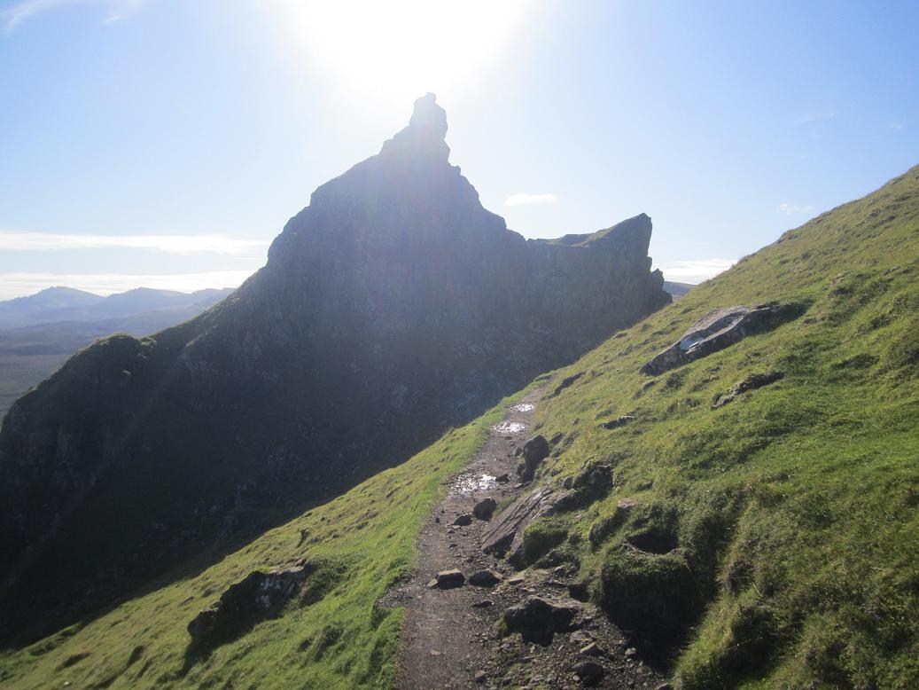
At the top of Benbrack stands one of the "Striding Arches", and as I jogged passed it I nearly started descending the wrong way off the hill. You're supposed to take a sharp left turn by the fence here and I probably missed an arrow on a post somewhere.

My running was a little smoother now and my mood lifted as I got back below the cloud and saw the way ahead over the next hills. I was back to enjoying doing what I enjoy, and feeling a little lucky that the rain had passed and hadn't just settled in for the day.

Surprisingly, running through forest was the exception rather than the rule today, and so it was quite a pleasant change to be routed into the trees along a heathery firebreak, arriving at Allan & Gracie's cairn (victims of the "killing-times" late 1600s). A peculiar spot, and yes, "lonely" again.


The way eventually drops down (through presently-felled forest) to the high watershed of several burns on which sits Polskeoch Bothy hidden by sitca spruce until the last few strides. I had a "nosey" inside, unsurprisingly empty and carrying the usual bothy smell, but in great condition. I leafed through the last couple of entries in the log, and couldn't help but feel the seclusion that S.U.W. hikers must feel here, especially if they'd covered the 17miles I'd just logged from Dalry (after numerous other days in remote places).


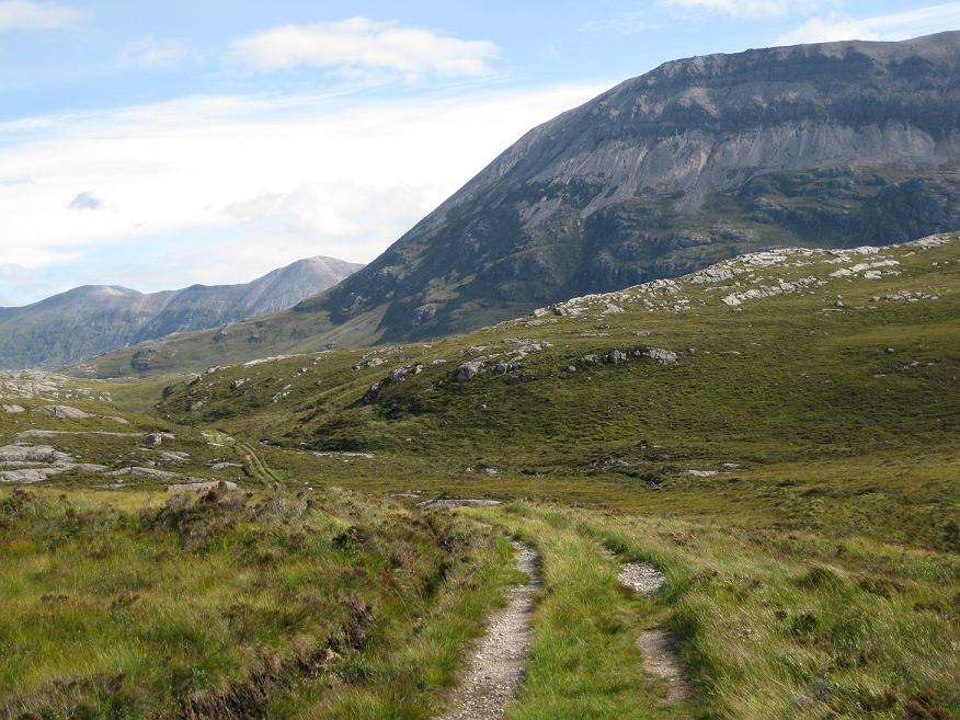
The bothy felt no less remote for being half-a-mile up the glen from Polskeoch Farm (B&B), proudly flying the Saltire. The farm sits at the terminus of a single-track tarmac road leading back down the Scaur Glen in search of civilisation. The way follows this road down for 2.5miles, and whereas in the past I'd have enjoyed striding out down the tarmac for a bit, today I was grateful to get back off onto the grassy hillside, enjoying a justifiably slower-pace as the trail gently climbs above the glen. Actually this was my favourite stretch of today's run, partly because the hillsides weren't cloaked in monotonous spruce, and also the grassy undefoot conditions were so pleasantly runnable, the way gaining height gradually and providing views both down the valley and back to where I'd been earlier.


I would soon be able to see down the otherside of "cloud hill" into upper Nithsdale and civilisation! As I noted from other's accounts of walking the way, you see Sanquhar a lot sooner than you reach it. My dad was on his way up from there, and we met about 3miles above town. I was glad he did get a walk in before the weather deteriorated as forecast.


My supportive dad squinting into the gale (Sanquhar behind)

I continued down into town, located the car as had been described (although I lost my Southern Upland Way by the river), and guzzled some water with half a nuun tablet. I felt great considering, and only had 7.4miles to go to Wanlockhead. Given the short distance remaining I decided to head off without the pack and really enjoyed the immediate feeling of lightness as I headed out of town and back up into the hills.

I was now entering the Lowther Hills, and what was particularly nice was being able to look back over town at the range I'd been running through earlier. I was really enjoying this now, even though the hills ahead were dark and the clouds upon themeven darker. I'd taken my jacket with me and was way-too-warm at first but knew that would change as I climbed back up above 400m. I stopped and took once last look behind me over Nithsdale before dropping down the remote side of the hill into a den with an abandoned farmhouse labelled "Cogshead" on the map. With only 3.5miles to go, and with my over-enthused pace, I "hit the wall" as marathoners know-it and started to struggle as the route climbed back out of the den almost summiting the 515m Glengaber Hill, the wind and light-rain really buffetting me now. I managed to keep the run going though, and was glad to be dropping down to the Wanlock Water beneath the scars of bygone lead-mining. The gusts of wind twice brought me to a standstill, and I was dizzy with low blood-sugar, but Wanlockhead was now in sight and soon I was enjoying a pot of tea and some soup with my dad in the Mining Museum Cafe.

Southern Upland Way Stages: Prev [1] [2] [3] 4 [5] [6] Next

Monday, 16 May 2011

Anoach & Rannoch

Distance: 28 miles (45km) Ascent/Descent: 1820m/1870m
Start/Finish: Dalwhinnie to Rannoch Stn
Terrain: 40% gravel/surfaced road, 30% hillside, 30% ridge-top trails
Transport: train stations at start/end. citylink bus services both places
Route: Route Map | Garmin Course

Summary
One of my first ever "ultra-distance" runs was from Dalwhinnie to Ft. William - accompanied by a chap Mike Thompson as part of our training for the West Highland Way race back in November 2008 (see photo below). And what a fantastic introduction to long distance routes - from the very remote Ben Alder Forest to the much more populous but very scenic Glen Nevis. The route described in my blog below follows the same good track as far as Loch Pattack, but for added stupidity I took in the "Anoach Four" ridge of Munros to the North of the Bealach Dubh, dropped down to the Bealach then went Munro bagging again on my way down to Rannoch. The sensible way is of course to camp or stay in Culra Bothy or Ben Alder Cottage en-route. And/or use a bicycle.


(A Wintery Ben Alder during Dalwhinnie-Ft. William run, Nov 2008)

Blog
Again I was teamed up with my dad for another weekend of outdoorsy madness. We drove to Pitlochry Station with unstable clouds above, as forecast, but the day promised to deliver fine views when you weren't up in the clouds, or getting soaked by every kind of precipitation known to man.
Nice to meet cyclists and other walkers waiting for the train. My dad was driving off to a point near Rannoch Station, he was doing his first "Solo" climb of a Munro for years (Carn Dearg) and I was hoping to catch up with him much later on during his descent, all things going well. We had a walkie-talkie each.

I was a bit confused on disembarking the train at Dalwhinnie as the sun was shining - that's not what usually happens here. Jogging back over the railway tracks and onto the NW shore of Loch Ericht, I got the much-anticipated feeling of "heading out into the wilds", and it felt damn good. Of course, the estate landy track is very much a road these days so its hardly wild at all - but as you walk, pedal or in my case run down it, you know that the place it takes you is very remote and embraced by some fine mountains and corries.


The track eventually (6-7miles) climbs gently away from the loch then descends towards Loch Pattack - those not heading for the Anoach Ridge would most likely turn-off the path onto a lesser track directly towards Culra Bothy and the wonderful Bealach Dubh beyond.

As I passed the curious estate ponies, I noticed the hillside beyond Loch Pattack became psychedelic. I was looking through a very low-angled rainbow - lots of sunny rain going on today.

Its little credit to the imagination of those tasked with naming Scottish mountains that both my first and last hill of the day were "Carn Deargs". Red Hill. My route choice onto the ridge of Carn Dearg No. 1 was a tad unorthodox (if orthodox is defined by the SMC books or munro-bagging websites), in that I decided to abandon the track at the top of Loch Pattack and pick my way up through the heather, moving from one burn to the next trying to find the easiest ground. This worked out ok as the going wasn't too steep until higher-up, by which point I was on exposed, windclipped terrain and knew I could look forward to much easier running from then on! In theory. In practise, it was me who got windclipped, and I was very quickly putting on hat, gloves, and after spinning around like a dog chasing its tail I finally got my other arm into the goretex too. The mountain forecast had warned of extreme gales and severe windchill, and snow on the summits, and possible thunderstorms, and for the likes of me and my dad the intent of such warnings never fully sink in until we're sober and 850m up a 1100m mountain and unable to individually move our fingers. The cloud was rushing past just metres above my hood. Was I still having fun? Not as much as I had been earlier, due to a bit of dread about trying to run into that cold gale along a high-altitude ridge for the next 5 miles. I soon cheered back up again, because after ascending into the cloud, picking up traces of Munro-baggers path, then cresting the boulder-strewn summit of Carn Dearg, the cloud lifted to reveal a stunning view of Lancet Edge and Ben Alder's Short and Long Leachas, all in partial sunshine (title photo). Even the conical Schiehallion could be seen, and later today the knobbles of Glencoe - visibility was excellent between the clouds and the squalls. (Hint: Don't look for the knobbles of Glencoe on a map).


I was grateful for the shelter afforded by the mass of Gael Charn ahead, so I stopped and admired the situation and enjoyed feeling my fingers again. Loch an Sgoir beneath me, Lancet Edge beyond, Long Leachas beyond that.

My route ahead looked inspiring, with a narrow waterfall cutting its way down the cliff to the left like a strike of lightening, two lochan-filled corries glimmering beneath me, one to each side, and a stony ridge ahead which I was chuffed to manage to run up without resorting to a walk. Just before I was back in the cloud I could see I was now above Lancet edge, and level with the banks of old snow. Very quickly I was upon the plateau, and glad to let the Garmin keep me on a bearing straight for the summit cairn about 1/2 mile away, surrounded by small drifts of fresh snow at 1132m.


Again the cloud was kind enough to lift briefly for me, and I could see Anoach Beag ahead, and Beinn Eibhinn beyond. Fortunately the uphill bits were sheltered from that wind so it wasn't as tough as I feared, and I was getting a lot more views and sunshine than I'd expected today.
I got briefly disorientated on descending Beinn Eibhinn in cloud as the ridge curves subtly Northwards and although I'd cut off to the left I was actually still running more W, not S like I imagined. My excuse is I was too busy picking my way through the boulders! But at least I got an unexpected view of forest above Fersit and the reservior once beneath the cloud, which fortunately I recognised as not being Loch Ossian! I corrected my course, apologised to my garmin for ignoring it and descended rapidly into much warmer climes of the Uisge Labhair glen. I took an overdue drink from a burn and refilled the hydration bladder from it, along with a Nuun tablet. Got down to the river, decided the best way across was to get wet feet so just waded through it then started piking my way S and SW up the hellishly heathery slopes of Sgor Choinnich. Bad route choice. I was heather bashing, and after 21miles of running I no longer had the strength to keep it going so was reduced to a walk-jog-gasp-look-at-the-scenery-a-lot-more method of progress. Once back onto the windclipped higher hillside (and putting the goretex back on as the rain came down) I was able to get into a shuffling jog again but it wasn't as enjoyable as before - I was burning fat now, and last night's bottle of Leffe. I could see Carn Dearg No. 2 in the distance. Walkie talkies work best with line-of-sight so I decided to try make contact with me dad. Contact made - he was sheltering at the summit cairn, good on him! He was also cold so he said he'd start his descent back S along the ridge towards the car parked at the base of "the Road to the Isles". It was re-assuring to make that contact though, and know we were both okay.


Briefly back into cloud for the last time, I ascended the "top" of Sgor Chonnich then took a run at the shapely Sgor Gaibhre, reaching the top with relief rather than elation.

Certainly felt good to be stretching the stride back out down the other side, W towards Mam Ban (thank you Wham). Rain showers, still accompanied by sunshine, now turned to hail as I made my way onwards to Carn Dearg No. 2 where my dad had been radioed earlier.

The hail passed and it was much nicer to us from then on. I made good progress down the ridge and soon caught up with my dad, who seemed to have taken my hip injury off me. We made our way safely off the hill from there after a very long, testing, but satisfyingly adventurous day out in the Scottish wilds.