A runners perspective


I hope this blog is of use/interest to walkers, runners and cyclists living in or intending to visit Scotland. Most of my entries below are described as long-distance runs - just because that's currently what I enjoy doing...

Saturday 6 October 2012

Ryvoan Bothy Circuit

Distance: 27.3 miles (44km) Ascent/Descent: 420m/420m
Start/Finish: Choice of Aviemore, Boat of Garten, Nethy Bridge or Glenmore Lodge
Terrain: 85% easy gravel, 15% quiet road
Transport: train and citylink bus serve Aviemore.
Route:
map
An Lochan Uaine - between Ryvoan Bothy and Glenmore Lodge, Cairngorms


Summary
This route is so popular I feel like one of the last outdoors enthusiasts in Scotland to have done it! Lesley had cycled it many times before, a girl at work had also reccommended it, and during breakfast at our accommodation in Boat of Garten, our host went and suggested it too! Not that we were particularly in the mood for a "mission" after a late Friday evening in the Boat Hotel! I can now see why its such a favourite - rarely on road and passing through forest, mountains and moorland, yet mostly flat and easy going (just one or two brief parts that require care if on a bike). And there's some gems en-route such as "The Green Loch". In spite of all the endorsements there is only a short section of the route which felt "busy" this weekend. The views deeper into the Cairngorm wilderness really caught my imagination for future exploration.  

River Spey, near Nethy Bridge, Cairngorms behind

Blog
Low morning sun in Abernethy Forest

I've mentioned before that September/October is my favourite time in Scotland. Okay it was baltic, but we were lucky to wake up to blue skies, still air, frost on the ground. Boat of Garten was silent, the air tinted with woodsmoke. We extracted Lesley's bike from the boot of the car and quickly got moving East out of the village via the bridge over the alluring River Spey.

Lesley pedalled along the road whilst I jogged along the adjacent "Speyside Way". It was probably only once we'd escaped the road, empty though it was, and entered Abernethy Forest that we really started to enjoy this journey, the groggy too-many-beers-last-night feeling being replaced with how lucky we were to be here! The pine forest had the ubiquitous carpet of heather, blaeberry and an occasional ant-hill. Blue sky above, dew sparkling in the sunlight, birdsong accentuated by the stillness, and now we'd done a couple of miles the coldness was refreshing rather than bitter (like the Guinness at Aviemore later). We shunned the road-side route of the speyside way to take the loop through the trees, then picked the "way" back up as it parallelled a single-track road for a bit then headed East again towards the wee town of Nethy Bridge (shop).
Start of "rights of way" to Braemar/Glenmore
After a break at the picnic tables by the River Nethy, we followed the road up past nice river-side homes we wish we owned, eventually onto gravel and back into the forest.  It was starting to cloud over now as we pedalled/ran deeper into the woods, a very subtle gradient taking us up towards Forest Lodge and the RSPB nature area.

 There was a choice of routes and we accidentally took the higher one up to Rynettin Farm, which was worth the extra effort for the view across the moorland into the Cairngorms proper, the higher points of which now carrying a dusting of recent snow.  It was a bit of a surprise exiting the forest and passing by a field of cows - with boarded-up farm buildings above - having seemingly left civilisation a few miles ago. 
Descending from Rynettin


An Lochan Uain
From here we were entering the mountains, but never having to climb them - the track dropped down from the farm to join the easier route that we'd missed, then undulates along the moorland, flanking the Corbett "Meall a' Bhuachaille" (also a popular walk in its own right, with a manicured path up to its summit from Ryvoan Bothy - this area was the only "busy" part of our day!  There's a hill race up Meall a' Bhuachaille in October, although this shuns the manicured route and goes straight up the side!).
View from a rock, into the wild (Cairngorms)


The rain was coming down as we approached Ryvoan bothy, so we took shelter there and were soon joined by many others.  Lesley produced the hip-flask, obviously trying to slow me down!  She didn't need to worry as it was mostly downhill from here - although a bit of care is needed when cycling the immediate descent S from the bothy.  At the bottom of this hill is the beautiful An Lochan Uaine (Green Loch), so time for another stop.
The path was manicured gravel from here to Aviemore, and provided a nice alternative to the surprisingly busy Glenmore Lodge road.  We broke the journey at Aviemore (Guinness and food) and eventually got moving again for the final 5 miles along the speyside way (cyclepath) back to Boat of Garten.  The food was heavy in the belly but we weren't in a rush - this is another beautiful stretch of moorland with views over the cairngorms, just a shame the rain returned - very cold rain, arriving in squalls.  That's why I don't have a photo of this bit, but here's a blog with a stunning view of it:

http://westcoasthikers.wordpress.com/great-britain-2012/speyside-way/aviemore-to-boat-of-garten/


Saturday 11 August 2012

Glen Tilt and Beinn a' Ghlo

Distance: 23.5 miles (38.5km) 
Ascent/Descent: 1670m/1670m 
Start/Finish: Blair Atholl  
Terrain: 45% gravel, 40% Hill tracks, 15% road.  
Remote moorland but generally dry/firm underfoot
Transport: train station and citylink bus services Blair Atholl
Route: Route Map

Lower Glen Tilt

Summary
Glen Tilt is bicycle-heaven.  It forms a great through-route from Blair Atholl to Deeside which I used many years ago as a student when cycling from Fife to Aberdeen!  It also makes for easy walking/running acess into (or out of) stunning remote country.  Next to Glen Tilt but generally hidden from view are the broad rounded heather-clad lumps of Beinn a' Ghlo, which boasts three Munros.  This route takes in the summits of the Beinn first, then gives the tired legs an easy trot back down Glen Tilt.  Once onto the first summit of Carn Liath, the gradients are generally gentle and the cols are shallow which makes it all very runnable. There are great views over high moorland to the Cairngorms, but my favourite view is from the descent down into Glen Tilt.

Blog
With less than 2 weeks until the Grand Raid des Pyrenees, and only 2 weeks since enjoying a fantastic run at the Lakeland 100 race, I chose this run as a way of keeping the fitness ticking over, hoping not to do any damage to muscles that were still in recovery mode.  (My original plan for this loop was to return via Carn a' Chlamain - a Munro on the NW side of the Glen.  This adds 4 miles and 650m ascent.)

Memorial Stone - Carn Liath rising beyond
There's parking in Blair Atholl opposite the entrance to the Caravan Park, with shops nearby.  That's where I started from, going through the Caravan Park and along forest track to the Glen Tilt Car Park (an option to shorten the run a bit!).

Beyond the old bridge over the River Tilt, a single-track road leads E up to Loch Moraig, making relatively easy work of the first 200m of today's ascent.  (There's a small car park up here - full by the time I was jogging past after midday).

A gravel track branches off to the NE, the gradient remaining gentle, then after a mile of this it was time to start climbing proper, forking N over a small crest, past a couple of huts, and once through one of the only areas of bog I'd encounter today.

Braigh Coire Chruinn-bhalgain (1070m),
with Carn nan Gabhar to R (1129m)
It was an enjoyable climb up Carn Liath, a climb that gets steeper with height, where the trail became loose gravel.  Zig-zags helped me keep a gentle upwards shuffle going.  I should really be practising 'power-walking' up hills but the shuffling feels easier on fresh legs.  I think.  Fast low cloud clipped the summit above, and sure enough once out of the shelter and onto the final gentler rise to the summit cairn it was time to put the jacket on and cut out that windchill!  From here, the running is much easier and there is a rough path to follow.  Beinn a' Ghlo is higher than much of the surrounding countryside so on the right day its a great viewing platform.  The ridge snakes downwards a bit from here, first heading NW, then NE over a lump, then N down to a bealach where there's an opportunity to fill water bottles without losing much height here if you contour N for 300m. 

Some more "snaking" E then N along increasingly rocky and broadening ridge before the next summit is reached.  Already there's only one significant climb left for the day, which suited my still-recovering legs just fine!  The cloud lifted again and I could see far into the remote country to the NE - basking in sunshine - with the Cairngorms clearly visible beyond.

Looking from Airgoid Beinn SW back over Carn Liath
I took in the top of Airgiod Beinn (view above) before climbing the final Munro of the day, Carn nan Gabhar. 

Looking back S towards Carn nan Gabhar
Now followed 2.5 miles of easy downhill running along the N continuation of Beinn a' Ghlo, then NW over Meall a' Mhuirich (898m) following traces of path.

The sun was really shining, the jacket was off again, a feeling of being on-top-of-the-world, happy days!

Descending through the heather towards the beautiful Glen Tilt
Dail Feannach above Glen Tilt
Dropping down into Glen Tilt requires a bit of care - its very steep, the heather is tall, but there is what I assume to be an old and little-used stalkers' path which is well worth finding as it zig-zags safely downwards.  (Don't be tempted to drop down towards Dail Feannach like I did - just stay on the direct line for Glen Tilt, aiming for the footbridge as soon as you see it, and you're very likely to find the path I refer to).

Looking down Glen Tilt, 9 downhill miles to go!
A great place to fill the bottles


After enjoying the sunshine for a moment, sitting by the cascade and re-filling the bottles, it was time to pick up the pace down the easy track. The sunshine was such a bonus - it hadn't been forecast! And it was very warm too.  There were a few mountain-bikes chained to fences along the glen, which makes a lot of sense for exploring the hills around here.

With only 4 miles to go the glen begins to twist and drop a little steeper.  There is a final short rise to overcome before arriving at the Old Bridge of Tilt, from where the route rejoins the first outward mile.  A great accessible day out.


Saturday 26 May 2012

Etive Peaks and Glen Kinglass

Distance: 27 miles (43km)  Ascent/Descent: 3050m/3050m 
Start/Finish: Victoria Bridge (Loch Tulla) 
Terrain: 55% hill trails, 15% pathless, 20% gravel track, 10% easy trail  
Transport: citylink bus stops at nearby Bridge of Orchy 
(Ft. William/Skye - Edinburgh/Glasgow services)
Route: Route Map
 
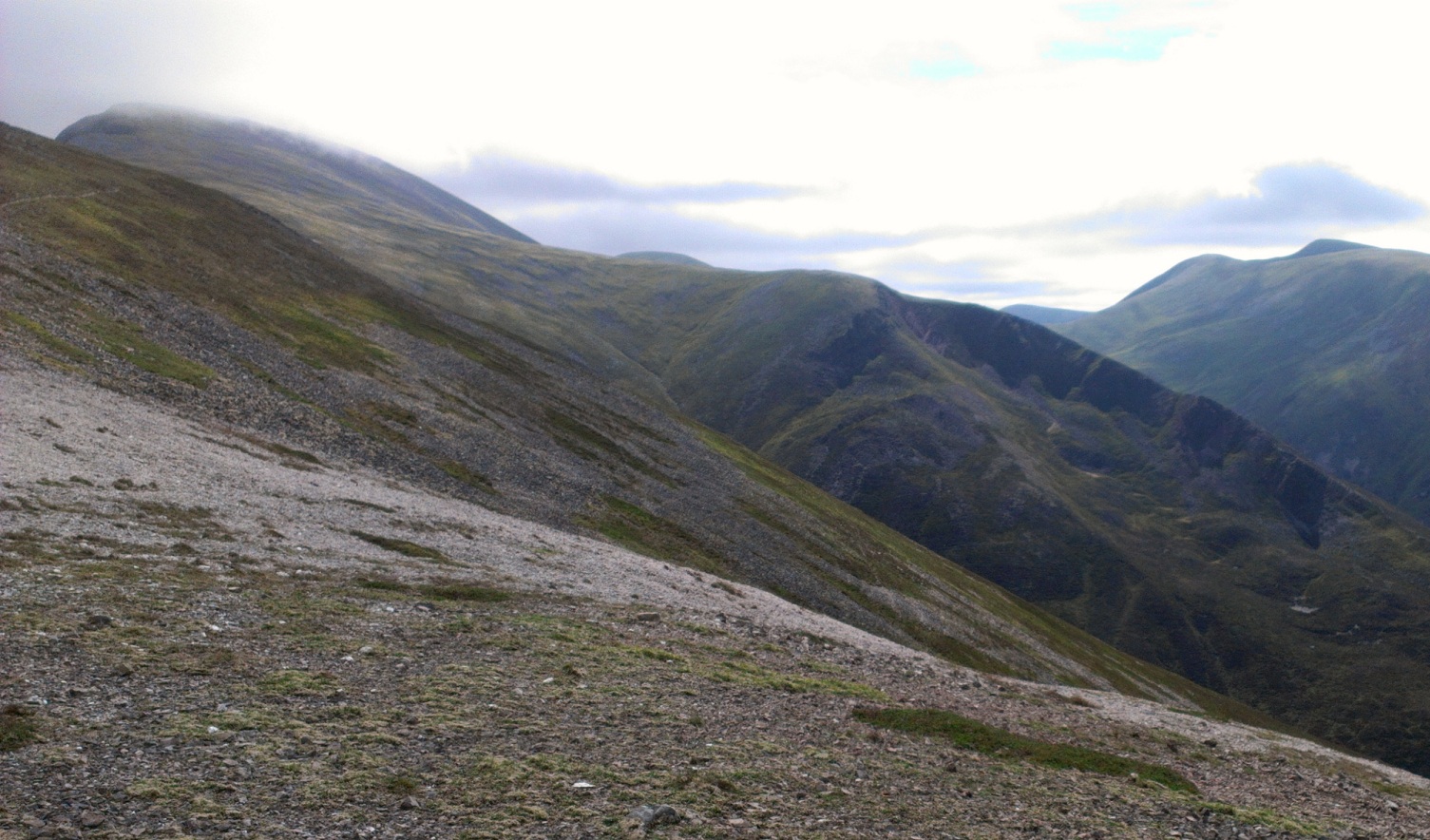
Looking North over Glen Etive towards the summits of Glen Coe

Summary
Today's run was less "Exploring Scottish Trails" and more "Obsessive-compulsive Munro Bagging" in the sun. Starting from Victoria Bridge (by Loch Tulla on the West Highland Way), it takes in the group of summits stretching between Rannoch Moor and Glen Etive, starting with Stob a Choire Odhar, eventually reaching Ben Starav beside the stunning Loch Etive, before returning via Beinn an Aigenan along Glen Kinglass to the start. This last bit is just part of a nice trail that runs West from Victoria Bridge (on the West Highland Way) to Loch Etive, where it meets another trail that runs North/South from Tayinult to Glen Etive. Forgetting summits, both these options offer nice scenery away from roads and towns - and would also make good mountain-bike trips (as evidenced by tyre tracks in the bog!).  

Blog
We parked at the gravel car park by Victoria Bridge – this is a popular camping area for those doing the West Highland Way or bagging Munros. When Lesley and I stepped out of the car the wave of heat that greeted us was very un-Scottish. The boggy ground by the road was dry and dusty. Lizards crossed the gravel path in front of me as I made my way Westwards along the stoney track into Glen Kinglass. Staying hydrated was going to be the main challenge for everyone today.

Good track up onto the ridge of Stob a Coire Odhair
 I followed the Munro-baggers route that forked N off the main track and gently up into the jaws of Coire Toaig on a path that made for very enjoyable running. My first summit, Stob a Choire Odhair, was hidden from view by the steepness of its heathery lower slopes. Immediately after crossing a river and stopping for a chat with a couple, enjoying a rest by the soothing sound of fast-flowing water, I forked right to take the Munro-baggers’ route, climbing steeply up eroded heathery hummocks by the river's NW bank. I was reduced to a walk until the gradient lessened and joined an old zig-zagging stalkers' path up towards the the stoney summit, a fine viewpoint over Rannoch Moor, in fact a fine viewpoint all around with the Black Mount to the N and to the W the mighty Stob Ghabhar.   That's where I was heading next.

After another brief chat I was heading down the not-too-steep W ridge of "Odhair", picking up a bit of a path down to the 668m pass, then continuing along the ridge ahead that curves more S and becomes rocky. Even though the path zig-zags a bit, I was still reduced to a walk on this stretch (something I need to practise anyway so I can survive the longer mountain events!).

Stob Ghabar
The lochan in Stob Ghabhar's NE corrie came into view below - an impressive setting. Having attained the crest of the mountain's SE ridge, it was an invigorating run up to the summit cairn where I was labelled "a nutter", and instructed to "make sure to drink plenty water".  I guess she figured anyone stupid enough to run up Munros is likely to need all the advice they get.

From here onwards I was covering unfamiliar ground.  That's the bit of a run I always enjoy most!  Descending slightly N of W along a broad, grassy ridge, I felt (and knew) I was leaving the crowds behind and entering lesser travelled territory for a few miles.  The views from this elevated platform were particularly good, especially North over the Buachaille Etive Mor and Ben Nevis above and beyond.

Ben Nevis standing high above the Buachaille
I had to drop down a bit to get fresh water for the bottles before traversing increasingly awkwardly back onto the ridge (much easier to stick to the crest!). Meall nan Eun looked diminutive from up here, and yet it was a long loop to the N before I could get onto its slopes from a bealach down at 633m! Descending to this needs a bit of care with a couple of crags needing "turned", so a bit of zig-zagging required before I got safelt down, picking my route onwards onto Munro 3 of the day. There's a fairly obvious grassy terrace to aim for (in good visibility) a couple hundred metres to the W of the old boundary wall, so I aimed for a gap in the outcrops where a burn flows down (186 458), finding evidence that this is where other walkers (and/or deer) head for.
Stob Coir a' Albannaich above the bealach before Meall nan Eun
Up onto the terrace, now just walking, its possible to start heading more SE through the gentler outcrops and attain the runnable plateau in search of the summit cairn, which even on this clear day was a bit shy! Its a 4.5mile mountain run from Stob Ghabhar to this summit, and being less-travelled I'd enjoyed having it all to myself. This was probably as remote as the route would get. From the small cairn I was almost doubling back on myself (NW) over the tundra to eventually continue W via Meall Tarsuinn - finding myself a good path upon its crest and down to the bealach beyond, with "Peak of the corrie of Scotsmen" ahead of me, Munro No. 4, and once again I was seeing others out enjoying this ridiculously fine day. Although hot down in the glens, the warmth was pleasantly temperate up here on the ridges. Everyone was wearing their brimmed hats.

From the bealach, Stob Coir an Albannaich’s rounded summit is attained via its ESE ridge (very much following the boundary on the map). The route onto this ridge is basically a gently-angled series of slabs with traces of path to the E of an obvious gully. Once onto the ridge it was again very runnable to the summit, where I became aware how close I now was to Glen Etive, its partly-forested base nestled amongst the array of fairly sharp peaks south of Glen Coe.

Glas Beinn Mor
Onwards to Glas Beinn Mhor was great fun - starting with a gently sloping area of high tussock grass over which I headed SW, then more SE as soon as it steepened to keep on the crest. Again basically following the line of the boundary marked on the map. Much easier on a clear day like today, I was eventually picking up traces of path, zig-zagging more steeply down to the 738m bealach beneath Glas Beinn Mor where a very well-todden trail starts the final climb to the summit. A bit of walking and then running to the top, and I was now looking directly across to the mightly-looking Ben Starav! The ridge up Ben Starav has plenty character, climaxing with a bouldery arete (bypass path if required) running between the pyramidal Stob Coire Dheirg and Starav’s SE top, from which one of the nicest mountain views in Scotland is to be had, with Loch Etive down below and the Atlantic Ocean beyond, Mull and Ben More looking not too far away at all.

Stob Coire Dearg, with the SE top of Ben Starav behind
 It was much busier over these latter mountains – lots of people making the most of the weather. But it would soon get quiet again once I’d retraced my steps back down to the Bealach and taken a path SE from there, dropping from the main ridge and aiming for the final Munro of the day – Beinn nan Aighenan.
Loch Etive from Ben Starav (Ben Cruachan visible top left)

It turns out there’s a path nearly all the way from the bealach to the top, although it does peter out in a couple of places. It’s a fairly isolated Munro, but there are still fine views over Loch Etive with the Cruachan range not too distant ahead.
 
Looking N to Meall nan Eun over Loch Dochard

A last glance behind up the Glen, near Victoria Bridge
Dehydration was setting in – there’d been very little opportunity to fill the bottles without descending too much off the ridge. As a result my legs were sluggish and my day quickly became more “endurance” and less “enjoyment”. Well I suppose I am in training after all. The worst problem was how long it was going to take me to get down off the Beinn’s slabby, twisting E ridge to a burn to refill the bottles! I don’t recommend my route choice here as the terminus of this ridge is rather steep over a succession of slabs. Taking this E ridge is fine so long as you don’t try and “cut the corner” for the bridge down in Glen Kinglass like I did – and instead stick to the crest as it swings S for a few hundred metres, before beginning to descend.

With hindsight I think I’d have been better just heading SE off the summit into Coire a’ Bhinnein where there’s water, and also a path marked on the 1:25000 map.

When I eventually did get the opportunity to rehydrate, life slowly came back to the legs and I could enjoy running down the glen with the evening sun, still very warm, hitting the hills I’d visited the tops of earlier. I particularly liked the view of Meall nan Eun across the loch, now looking up at it rather than down from it.

The path joins a dirt track then leaves it again (crossing a dodgy suspension bridge to the N bank of the river), making its peaty way back towards my outward route this morning, then eventually the car at Victoria Bridge.

Friday 13 April 2012

Torridon and Damph Loop

Distance: 39 miles (62.5km) Ascent/Descent: 1220m/1220m
Start/Finish: Strathcarron Station
Terrain: 50% good trails, 25% Forest track, 15% Vague/Rough trail, 10% surfaced road
Transport: train station at Strathcarron (infrequent)
Route: Route Map


Looking back N over Glen Torridon towards Beinn Eighe (from Bealach Ban path)

Summary
This loop takes in two passes through the mountains between Strathcarron and Torridon, including a scenic trail through the Torridon giants of Beinn Alligin, Liathach and Beinn Eighe. At time of running, refreshments were available at the nice store/cafe in Torridon village.  This is a wonderful area to explore by foot, with numerous tracks cutting between steep-sided mountains.  I ran the loop clockwise, which has the advantage of tackling the roughest part of the day when freshest.  However, I had to regularly stop and look back as the opposite direction seemed to offer the best views.  (I have no problem with regularly stopping and looking!)

Blog
Looking over the head of Loch Carron from above Tullich
 Inspiration for most of my running routes come from just staring at OS maps, joining together paths that look like they go through somewhere interesting.  If I'm greedy my route choice gets distracted by nearby Munros or Corbetts.  On this occasion I'd already sated my appetite for summits having done the South Shiel Ridge a couple of days prior (and the fact I'd visited most of the summits in this area in the past) I was keen to explore the tracks through corries and bealachs instead. 

My day's run started at Strathcarron Station at the Southern-most point of my loop.  The sky was clear and the wet, brown hillsides were lit by a low sun.  I'd had to scrape ice off the car this morning.  I settled into an easy run along the road to Lochcarron.  My route of escape into the hills was at the gate for Tullich on the A896 (there's a gate on right-hand-side with waymarker arrow).  The arrows took me on a non-intrusive route around the houses, the boggy path still frozen in places, then I was onto a very wet and rough track into the hills.  I eventually lost this track in bog.  The OS map suggested the route was on slightly higher ground to the W, so I ascended, following some deer for a bit, then came across old mossy cairns and traces of path again.  I found it hard work, but with hindsight I can say this was the hardest part of the day, both in terms of effort and route-finding.

Hazy ridges of Attadale, from the summit of Bealach a Ghlas-chnoic

Beinn Bhan (from E) over the Allt a Ghiubhais
Higher up the Bealach its easy to get routed away to the W by the course of the burn, whereas the "path" crosses this and heads NW over rocky lumps where views open up down the other side.  From here a rough track winds down quite steeply at times back towards sea-level. 

Do not cross the bridge into the woods like I did - I quickly realised my mistake and retraced my steps back over the bridge and onto a less-obvious continuation of the track down towards the Moine Mhor.  My route disregards the OS map at this point and follows an unmarked but good track N across the wetland to Kinloch Damph at the base of Loch Damh.  Additionally, there is no longer a bridge over the river at Kinloch Damph - but your trailshoes will be soaked by now anyway so wading across is no problem.

Loch Damh
A wooden fingerpost by the ex-bridge marks the start of the "Loch Damh walk", a great loch-side trail that would take me over to Torridon without a road or car in sight (well until the end bit that is).  I stopped for a break above this beach (photo) as it was such a nice spot.  From here the wet trail proceeds through pockets of newly-planted native woodland before arriving at a fishing lodge, from where a wide track, presumably maintained for access to the fish farms, continues the route N down to Loch Torridon.  Beinn Alligin looked nice and sunny across the water, however the bulk of Liathach was cloaked in menacing cloud and it wouldn't be long before I'd get my first wee blast of hailstones.

The road alongside the incredibly clear and calm water of Loch Torridon


A hail shower moves across Loch Torridon, Beinn Damh behind
On reaching the A896 above the loch, I crossed the road slightly to the left where a new signpost marks the start of a good track along the shore (presumably an old section of road?) to Annat.  As I arrived at the Torridon Hotel, the grounds-keeper (I think, judging from the attire) approached and asked me if I was training for the Triathlon, which makes my run today look soft!  He told me there was a path that cut the corner to Torridon Village ahead, so its possible to do even less on-road running around the loch than I thought.  I missed it and continued on my planned route to the junction and the Youth Hostel, campsite and toilets.  A short jog down the road from here and I was enjoying a fantastic slab of carrot cake and cappuccino in the new cafe/shop, with a view back across the loch to where I'd been running earlier.

From here I was lured by a waymarker onto a nice trail above the road - another section of old road perhaps?  It was nice to be back off the tarmac but I warn you that you have to drop back down to the road when the next waymarker post tells you otherwise its a rough passage through boulders and scratchy bushes!  With hindsight I'd have just stayed on the road - which is very quiet and means I could look at the scenery for a bit rather than where my feet were going.

Looking E towards Beinn Eighe, snow on Liathach visible top right
Soon I was at the busy carpark beneath Beinn Alligin and the start of the track around to Coire Dubh - the next leg of my journey.  The first few kms along this trail are heavenly - a gentle slope and a feeling of progressing easily up into dramatic mountains!  A very low-flying propeller-powered aircraft (a Hercules?) rumbled overhead, just a couple hundred metres or so, it looked like it was coming down to land in the glen ahead! 


Liathach from the NW
The sun was shining again, and it felt warm for a moment while I stopped and chatted to a couple coming the other way.  As I progressed E behind the impressive bulk of Liathach, the terrain became very rocky, and progress became much tougher as the large boulders and bog broke up the rythym.  Hailstones were followed by snow, it became very cold when the sun wasn't shining and so the layers were on and off many times for the rest of the day.  Once past Loch Grobaig the route joins the very popular route to Beinn Eighe's Loch Coire Mhic Fhearchair (a fantastic wee walk in itself), and the progress is much, much faster along this good maintained track down to the road.  I didn't encounter anyone on this path in spite of the full carpark - everyone else must have been up on the summits!  From here my run followed the road for a short distance E over a bridge to a green right-of-way sign marking the start of the through-routes to Achnashellach and Coulags (my final pass of the day).

Liathach over Lochan an Asgair
This next section of trail was excellent.  A narrow gravel ribbon up past a waterfall and back into the hills.  I made fast progress up this at first, but as it steepened it also deteriorated and so I took a tactical picnic higher up with a great view (title photo) back N over the glen.

The gradient does eventually relent, cairns now marking the way on rocky but drier terrain as I found myself looking into Coire Grannda.
Coire Grannda
Bealach Ban
The way onwards for me was not into the Coire, but instead a SSW traverse, crossing the burn above a waterfall and picking up the excellent and obvious path over the Bealach Ban at 540m.  The path drops down steeply at first then contours SW to a junction with another path rising towards Bealach na Lice.  Here I turned left (downhill) towards the lochan below, the trail remaining good all the way down to the Coulags Bothy.  There was no one staying at the bothy when I took a nosey around.

Coulags Bothy

From here it was a gentle drop down to the road.  I was looking forward to my dinner by now - a family meal in the Plockton Hotel booked for 6:30pm!  After following the A890 Lochcarron road SW for a few minutes, I was able to escape the tarmac just before a picnic spot where a sign marks the start of a woodland walk to Strathcarron down along the river, where salmon pools are marked by signs ("Johnny's Pool", "Hill Pool").  The waymarkers lead me back to the road bridge over the river where it was a short final sprint along tarmac to beat the next squall.  Great day out (and just part of a brilliant week with family in Plockton).

Tuesday 10 April 2012

South Shiel Ridge

Distance: 27.5 miles (44km) Ascent/Descent: 2000m/2000m
Start/Finish: Cluanie Inn, Glen Shiel
Terrain: 30% gravel/surfaced road, 60% good trails, 10% ridge-top, mild scrambling
Transport:
citylink bus services Cluanie Inn (Gla/Edi - Skye service)
Route: Route Map


Descending on Maol Chinn Dearg

Summary
A munro-baggers' classic, this ridge of 7 munros lies to the South of Glen Shiel and the road to Skye. After completing the ridge from East to West, the route follows a stalkers path S into the remote Glen Quoich, and with most of the hard work done a great trail-run takes you back beneath the summits along Glen Loyne, then over a small Bealach to the estate road leading back to the Cluanie Inn.

Blog
I'm really glad I went for it. Leaving Cluanie Inn on the road to Cluanie Lodge, with the Loch still and reflecting snowy peaks, my sense of adventure was there but a bit dampened by the expectation that I'd probably encounter ice along the ridge and have to turn back.

A good track leading to the base of Creag a Mhaim
I enjoyed gaining height easily up this gently-graded road above Loch Cluanie, eventually to a 430m Bealach from where I started expecting to find a stalkers' path branching off onto the SE shoulder of Creag a Mhaim. The snow-level was only about 300m above here.

The path did appear on the right just before a little bridge, and it looked nice and gravelly and so very runnable. After a km or so this path forks - I was heading right up onto the ridge, but later today I'd be returning here from the left.

Loch Loyne from the SE ridge of Creag a Mhaim
The path up onto the ridge remained excellent, zig-zagging to take the sting out of the ascent and so I was quickly up into the snow. Surprisingly there were no bootprints in it!

As always it felt good to reach the summit cairn, cloud came down then back up and I was still getting reasonable visibility along the ridge ahead, which at this end is broad.

Druim Shionnach
The ridge doesn't drop much before ascending to Druim Shionnach, and as the snow deepened and ridge narrowed I stopped running and settled into a walk. Snow flurries came and went, but I was cosy in serveral layers and jacket (I also had a full set of spare dry clothes and gloves in the bag as I have a healthy fear of the cold!)

After some mild scrambling I was on the 2nd peak of the ridge and moving on, the NW wind beginning to pick-up as forecast.
Looking back E towards Druim Shionnach

I had a third text-message exchange with my dad, he now knew it was my intention to proceed.

Between the summits I was often back below the cloud base and taking in views down from the ridge, both sides, including back NE to Loch Cluanie. A couple of times I did try to run the less exposed downhill bits but the snow deepened as I headed W and rocks hidden by the snow made it a bit silly. And after the third summit - Aonach air Chirth - the ridge became a bum-cheek scramble along snow and rock. I didn't want to slip here. Fortunately nearly all the snowfall was fresh, and I did not encounter any ice.

Loch Cluanie in the distance
I met a couple of guys walking the other way, they were also surprised at the lack of people on this popular ridge, and said there'd been no other footprints along the way. Well they had mine to follow now, and I had theirs.
Final rise up Sgurr an Lochain (rusty fenceposts!)

The narrow ridge of Maol Chinn-Dearg was a highlight (title photo), being able to see down both sides. It goes over a bump and broadens back out to the summit at 981m, then the ridge remains relatively broad from there as it descends over a subsiduary top down to an 820m Bealach. It was along this section when the air filled with high velocity polystyrene balls. I pulled my hat and hood around such that I could only see with the left eye. I also changed gloves. For the next hour or so I didn't see much other than snow, rock, blizzard, and battered rusty fence-posts which appear along this section. I summitted Sgurr an Doire Leathain, ignoring the quickly-filling bootprints as I remembered to head slightly N from the main spine to find the summit cairn. Next was the penultimate Munro of the ridge, Sgurr an Lochain, which looks like a nice peak in other people's photos but I wasn't seeing much!
The head of Glen Quoich with distant Knoydart hills beyond
Descending steeply from there, I finally got out of the murk and found myself looking across at other mountains and blue sky to the W. The snow became slushy, it was melting fast, and the Munro-baggers' path re-emerged. I got a great view over the head of Glen Quoich to the Knoydart hills beyond.
Looking towards Sgurr Thionail from Bealach a Fraoch Choire
As I was already quite tired, I happily ignored the 896m lump on the ridge and kept to the Munro-bagger's track which by-passes it to the S. This leads to Bealach Fraoch Coire, the lowest point of the ridge. From here I power-walked back up into the snow one last time to reach the lumpy summit of Creag nan Damh, then retraced my steps to the Bealach to pick up the top of an old zig-zagging stalkers' path down (S) into the remote Glen Quoich. This path hasn't been maintained, it was mossy, steep and greasy (yes I had a couple of slips). But it is nonetheless a reasonably safe route down onto the brilliant trail along the glen.
Looking down Glen Quoich towards Gleouraich
I was really glad to reach the river-side track. After the slow progress along the snowy ridge, I immediately enjoyed this very-runnable trail back E, down to Alltbeithe then gently back up to the watershed of the River Loyne.
Looking back (W) up Glen Loyne
There was one last climb to do, which was a left fork back up between the lower slopes of Creag a Mhaim and the 500m lump marked "Craig Liathais" on the OS map. I took a much-needed breather ascending this lump (somehow my phone received a text message here - my dad asking me to update if I had reception which I didn't!). I was grateful to get over this last "hurdle" and be heading back down into civilisation, now able to reply to my dad's text to let him know I just had an easy few miles down to the car. Not the sort of day I'd expected after the recent mild weather, but entertaining for sure.