A runners perspective


I hope this blog is of use/interest to walkers, runners and cyclists living in or intending to visit Scotland. Most of my entries below are described as long-distance runs - just because that's currently what I enjoy doing...
Showing posts with label trail. Show all posts

Saturday, 11 August 2012

Glen Tilt and Beinn a' Ghlo

Distance: 23.5 miles (38.5km) 
Ascent/Descent: 1670m/1670m 
Start/Finish: Blair Atholl  
Terrain: 45% gravel, 40% Hill tracks, 15% road.  
Remote moorland but generally dry/firm underfoot
Transport: train station and citylink bus services Blair Atholl
Route: Route Map

Lower Glen Tilt

Summary
Glen Tilt is bicycle-heaven.  It forms a great through-route from Blair Atholl to Deeside which I used many years ago as a student when cycling from Fife to Aberdeen!  It also makes for easy walking/running acess into (or out of) stunning remote country.  Next to Glen Tilt but generally hidden from view are the broad rounded heather-clad lumps of Beinn a' Ghlo, which boasts three Munros.  This route takes in the summits of the Beinn first, then gives the tired legs an easy trot back down Glen Tilt.  Once onto the first summit of Carn Liath, the gradients are generally gentle and the cols are shallow which makes it all very runnable. There are great views over high moorland to the Cairngorms, but my favourite view is from the descent down into Glen Tilt.

Blog
With less than 2 weeks until the Grand Raid des Pyrenees, and only 2 weeks since enjoying a fantastic run at the Lakeland 100 race, I chose this run as a way of keeping the fitness ticking over, hoping not to do any damage to muscles that were still in recovery mode.  (My original plan for this loop was to return via Carn a' Chlamain - a Munro on the NW side of the Glen.  This adds 4 miles and 650m ascent.)

Memorial Stone - Carn Liath rising beyond
There's parking in Blair Atholl opposite the entrance to the Caravan Park, with shops nearby.  That's where I started from, going through the Caravan Park and along forest track to the Glen Tilt Car Park (an option to shorten the run a bit!).

Beyond the old bridge over the River Tilt, a single-track road leads E up to Loch Moraig, making relatively easy work of the first 200m of today's ascent.  (There's a small car park up here - full by the time I was jogging past after midday).

A gravel track branches off to the NE, the gradient remaining gentle, then after a mile of this it was time to start climbing proper, forking N over a small crest, past a couple of huts, and once through one of the only areas of bog I'd encounter today.

Braigh Coire Chruinn-bhalgain (1070m),
with Carn nan Gabhar to R (1129m)
It was an enjoyable climb up Carn Liath, a climb that gets steeper with height, where the trail became loose gravel.  Zig-zags helped me keep a gentle upwards shuffle going.  I should really be practising 'power-walking' up hills but the shuffling feels easier on fresh legs.  I think.  Fast low cloud clipped the summit above, and sure enough once out of the shelter and onto the final gentler rise to the summit cairn it was time to put the jacket on and cut out that windchill!  From here, the running is much easier and there is a rough path to follow.  Beinn a' Ghlo is higher than much of the surrounding countryside so on the right day its a great viewing platform.  The ridge snakes downwards a bit from here, first heading NW, then NE over a lump, then N down to a bealach where there's an opportunity to fill water bottles without losing much height here if you contour N for 300m. 

Some more "snaking" E then N along increasingly rocky and broadening ridge before the next summit is reached.  Already there's only one significant climb left for the day, which suited my still-recovering legs just fine!  The cloud lifted again and I could see far into the remote country to the NE - basking in sunshine - with the Cairngorms clearly visible beyond.

Looking from Airgoid Beinn SW back over Carn Liath
I took in the top of Airgiod Beinn (view above) before climbing the final Munro of the day, Carn nan Gabhar. 

Looking back S towards Carn nan Gabhar
Now followed 2.5 miles of easy downhill running along the N continuation of Beinn a' Ghlo, then NW over Meall a' Mhuirich (898m) following traces of path.

The sun was really shining, the jacket was off again, a feeling of being on-top-of-the-world, happy days!

Descending through the heather towards the beautiful Glen Tilt
Dail Feannach above Glen Tilt
Dropping down into Glen Tilt requires a bit of care - its very steep, the heather is tall, but there is what I assume to be an old and little-used stalkers' path which is well worth finding as it zig-zags safely downwards.  (Don't be tempted to drop down towards Dail Feannach like I did - just stay on the direct line for Glen Tilt, aiming for the footbridge as soon as you see it, and you're very likely to find the path I refer to).

Looking down Glen Tilt, 9 downhill miles to go!
A great place to fill the bottles


After enjoying the sunshine for a moment, sitting by the cascade and re-filling the bottles, it was time to pick up the pace down the easy track. The sunshine was such a bonus - it hadn't been forecast! And it was very warm too.  There were a few mountain-bikes chained to fences along the glen, which makes a lot of sense for exploring the hills around here.

With only 4 miles to go the glen begins to twist and drop a little steeper.  There is a final short rise to overcome before arriving at the Old Bridge of Tilt, from where the route rejoins the first outward mile.  A great accessible day out.


Friday, 7 October 2011

Harris Walkway

Distance: 23miles (37km) Ascent/Descent: 590m/520m
Start/Finish: Luskentyre Beach to Ardvoulie
Terrain: 20% road, 60% Good path, 20% Swampy path
Transport: Bus Services for both start/end
Route: Route Map | Garmin Course


Summary
I can't understand why such a great official walking route receives such little promotion! I had never heard of the "Harris Walkway" until browsing through tourist brochures in the Hotel at Tarbert. Even the brochure offered a mere hint as to its existence - a set of straight dotted lines across a map of Harris, accompanied by just a paragraph with little clue as to what the actual route involved. So I got myself online and started searching the internet expecting to find dedicated pages about this "walkway" which was opened in 2001 by Cameron McNeish, but all I found was other walkers' exclamations at the lack of information available, along with sparse accounts and a couple of photographs.

Admittedly, on inspection of an OS map of Harris, and given the start and end points (Ardvoulie to the N of Tarbert and Selibost to the SW), the route any road-avoiding explorer would choose is fairly obvious. A series of old tracks cut through the hills of Harris, and the Harris Walkway basically links them together, with just a little bit of road walking in between.

Some work has gone into this walkway - sections are marked with a plaque at either end (many now faded), giving a brief description in English and Gaelic. Also every section has at least one strategically placed bench providing a fine place for lunch or a breather.

The excellent Hebrides Transport bus services visit both start/end points. I based myself in Tarbert (ferry from Uig, Skye), and in the morning took the bus down to Luskentyre, ran from there back to Tarbert, then at 4pm took a bus N to Ardvoulie and again ran back to Tarbert. It would make a pleasant, unstressful two-day end-to-end backpacking trip with plenty idyllic camping spots to choose from.


Blog
After cycle-touring slowly up the Uists from Barra during a stormy week, negotiating cancelled ferries and dangerous side-gusts, it made a nice change to wake up to a cloudless blue sky in Tarbert. Swapping bike shoes for trail-running shoes, I boarded a bus for Luskentyre, back over the rocky pass I'd pedalled over a couple days earlier, and the driver knew exactly where to drop me off to start the coast-to-coast first section of the Harris Walkway along the "Coffin Road". Some steps up from the road lead to a style (title photograph), and I found myself on an old section of moss-covered road leading me towards the Bealach Eorabhat.

The going remained easy and it wasn't long before I was at the summit, encountering the first of many benches on this walkway. The ocean was visible to East and West.
The continuation from there became much rougher, lots of leaping over bog and an occasional bit of sinking, tall marker-posts indicated the way down. After barely more than 3 miles I was on the other coast of Harris, where the route shies away from the possibility of tarmac and instead negotiates a rocky lump then meanders through one of the rockiest scenes I've seen in Scotland. Sure enough an information board declares that this area was used in Stanley Kubrick's '2001 Space Odyssey' due to its moon-like landscape.
After passing a lochan, a track joins from the right - this was my onward route, taking me down to the road junction and a plaque that described the "Coffin Road" I'd just followed.
From here at the head of Loch Stockanish, I followed the tarmac briefly uphill (ENE), until a tight left bend where a small gate (on the right) offers a route of escape back onto open hillside. A path is shown on the map from here, even though there isn't much evidence of one at first. Shortly I was once again encountering occasional way-marker posts and there became evidence of a seemingly old, well-engineered track, which these days resembles a carpet of marshy grass rolled upon the rocky terrain.
There was always a nice view over the complex coastline to the sea, and the hazy outline of Skye's Trotternish Peninsula was visible beyond. The route meets what's presumably an ancient T-junction, and after a quick consultation of the map I turned left to run initially steep uphill then attaining an impressive section of "carpet through the rocks".
It snakes down past a couple of lochans eventually arriving at a tiny place called Greosabhagh, and here a short but enjoyable bit of road-running begins. I never saw a vehicle on the 1.5 miles of road which took me to the start of the next section of old trail, with nice views of the Clisham Hills of North Harris opening up.
Another brief section of tarmac took me through Meavaig, just after which I spied the next little "plaque" on the right-hand side of the road, where a vague track skirts down the verge towards a very modern-looking wooden bridge. Again this is a section of "old road to Tarbert". The all-too-familiar dark clouds were back in the sky by this point, and so the rain was soon coming down to make sure I got soaked before I reached Tarbert. There's a final section of road, and a final small loop of old-trail, before reaching the port. From start to Tarbert, I'd clocked only 15 miles, and after a pint of 80 schilling in the Hebrides Bar I was up for seeing the final 8 miles, taking advantage of the scheduled 4pm bus to Ardvoulie so I could run back to "base" in Tarbert.
It was clear the heavy showers were back to stay as the bus took me North over a soggy Clisham Pass and down towards Ardvoulie. This part of Harris is much more mountainous. I spotted the usual "plaque" at the road-side and the driver kindly let me off the bus at an unofficial stop before Ardvoulie so I didn't have so far to run back uphill on the road! Sure enough a little sign here commemorated the opening of the Harris Walkway by Cameron McNeish in 2001.
The route starts off very soggy, but green-soggy rather than brown-soggy which meant I was probably a bit cleaner by the time I got to the top of the pass it climbs. I was really enjoying the afternoon/evening light when the sun did shine, I find its always special to be in places like this for the last few hours of daylight. One of the route's benches had been blown over up here, so I lifted it back into its right place (until the next storm hammers it in a week or two's time no doubt). Its a shame to see how faded the writing on the plaques are, some even cracked in half.
The walkway rejoins the main Stornoway-Tarbert road but not for long, and soon I was descending the road down to Loch Seaforth with nice views over the water. Near the bottom of this descent, another plaque marks the start of the final section of the walkway (in the twisted order I've done them, that is) back to Tarbert.
A couple of modern wooden bridges took me over waterfalls and the route continued almost roman-like in its straightness up the hillside. As always, the gradient was gentle and the pass was relatively low. A final bench offered the option of a break beside the Lochan nan Lachasdail, before the track climbed away to meet tarmac and the final mile West to Tarbert.

Saturday, 24 September 2011

Southern Upland Way: Bargrennan - St. Johns Town of Dalry

Distance: 25.1 miles (40.5km) Ascent/Descent: 490m/510m
Start/Finish: Bargrennan to St. Johns Town of Dalry
Terrain: 45% forest road, 15% surfaced road, 25% Rough trail, 15% Easy trail
Transport: Very limited: Dum & Galloway bus timetables, and Kings Coaches
Route: Route Map | Garmin Course

Southern Upland Way Stages: Prev [1] [2] [3] [4] 5 [6] Next


Summary
This section of the Southern Upland Way has a more "Highland" feel about it, crossing Galloway Forest Park near its more rugged peaks. It never ventures onto the higher terrain, keeping to the forested glens with only a couple of gentle passes involved. The character is always changing, from leafy riverside and lochside trail at first, to more open and desolate country scarred with expansive forestry, but finishing with a pleasant wooded descent (albeit on tarmac). A final modest climb up Waterside Hill is well worth the effort, giving the day's most open view of the surrounding countryside, with Dalry just an easy mile below.

Blog
Its been too long since we last did this! Back exploring the Southern Upland Way, and the surrounding area. September/October is my favourite time of year in Scotland - weather's still mild, but the midges aren't so bad, the heather's still out, the bracken is golden and the leaves are just starting to put on a show.

Just South of Bargrennan (I must have blinked when we drove through), there is a layby close to where the Southern Upland Way crosses the A714. The sun was reflecting brightly off the road, wet from a recent downpour. I knew from a phonecall with the Ken Bridge Hotel, where the campground was waterlogged, that today promised to be a very squelchy day.
I set off very relaxed onto the river-side trail, soon becoming less relaxed as the wet tree-roots seemed to be trying to send me down into the water! Reckon my socks were already soaked and my legs sprayed with bog within the first mile.

I overtook a couple of lassies taking their mountain-bikes for a walk, then the route did become firmer and the trees backed-off giving me a few glimpses of the surroundings. Yes it was boggy in places but all runnable and the river-side setting way very pleasant, I was happy to be back running the Southern Upland Way again.


After passing through the abandoned campsite at "Caldons", the character begins to change as the steep-sided and forested slopes of Glen Trool are entered. I was still feeling fresh enough to enjoy all the seemingly pointless short-sharp ascents and descents through the trees, and had to stop several times so I could take in the occasional view across Loch Trool.
I could see across to Bruce's Stone, and above it the trail through the Bracken which forms the start of the Merrick Hill race.

At the time I ran this, they seem to have re-routed the S.U.W. along the forest trail (sharing it with Cycle Route 7) instead of the way marked on my map (which heads ascends the same watershed but by a more open, rougher route). I didn't mind, don't think there was much difference between the views. There was certainly a difference between one side of the watershed and the other, however, as the land opened out and Loch Dee presented itself below. This was one of those sections which I think might be a bit tedious to walk - forestry road is fine in short stretches but mile after mile with squares of logging operation on either-side, not so great!
It did give me the chance to stretch-out the stride a bit, and so it wasn't so long before I was above Clatteringshaw's Loch, and looking out for my dad somewhere on the trail ahead. We met up where the route becomes a trail again, and I admitted to him he wasn't missing out on too much if he turned around to go back from where he was! I followed his footprints back up the squelchy/stoney path up a firebreak and out onto open moorland. Only 5 miles to go from here, and mostly downhill.
Which was a good job because my legs were beginning to stiffen up and I was ready for a pint or two. The descent went from trail to track to tarmac, my car sitting where my dad had left it so I could pick up a change of dry clothes and be slightly more presentable at the pub. The road down was pleasant enough - helped by lack of cars - but it was nice when a fingerpost sent me off it down to the riverbank instead. Over a bridge and into a field with a swamp and a bull in it, I sank nearly up to my knee in a marsh as I tried to keep as close to the fence and as far from the bull as possible.
Was glad to get to a style and onto bracken-covered hillside, and start ascending the final wee hill of the day, which was easier going than I'd prepared myself for. And nicer too - the view from the top, both looking back over the Galloway Forest Park from where I'd come, and forward over Dalry, the destination, with distant lake-district peaks visible.


Got to the Clachan Inn, two minutes later my dad was there too, and we were sitting in the sunshine with beer and a post-exercise buzz. We were both glad to be back to the "Southern Upland Way" project, and already making plans for the ultimate stage - Bargrennan to Port Patrick, where we have decided it would be nice to jog the last 5 miles together to complete what we started in the frosty early months of this year. We're both going to have to get a bit more training in!

NOTE: This is what this section of the Southern Upland Way does to your legs.

The next day (Sunday) we did a nice short walk in "Ness Glen" a few miles to the North by Loch Doon - a gem of a gorge walk.

Other Southern Upland Way Stages:
Prev [1] [2] [3] [4] 5 [6] Next

Tuesday, 29 March 2011

Trossachs Peaks and Trails


Distance: 30.5 miles (49km) Ascent/Descent: 1800m/1800m
Start/Finish: Aberfoyle, Kilmahog or Brig o Turk
Terrain: 80% Trail (various), 10% Quiet Roads/Track, 5% Wild
Transport: Citylink buses serve Callander (where route can be joined via bikepath), Aberfoyle Coaches serve the Trossachs
Route: Route Map | Garmin Course


Summary
A circular route that takes in the taller peaks of the Trossachs - Ben Ledi and Ben Venue. Although fairly modest in height, the summit of the latter is a dramatic place to be, seemingly surrounded by lochs and gnarly hills. As well as the drama of running along exposed hilltops, there's also plenty more sheltered running along the shores of lochs or in forest trails, but never boring, I promise!

Blog
I started today's adventure from the small carpark just a short distance down the A821 from Kilmahog. Cloud cloaked the upper hillsides, but at least it wasn't raining, and the air was still and peaceful, so much so that the lochs were like glass throughout the day.

I descended onto the Callendar-Killin cyclepath (one of my favourite marathon-training runs) and headed into the native woodland at the start of the Pass of Leny, a gorgeous place to start out on a run. Unfortunately I wasn't at my best today, with recent racing in the legs (Deeside 33 and Barcelona Marathon), but it didn't detract from the journey. I finally got to base of the manicured trail up Ben Ledi, and bounded up it with dumb enthusiasm, especially as I have never been up Ben Ledi before! Ridiculous, really, given its proximity to home and how much more interesting it is to many a Munro further afield. I doubt I'm the only one guilty of generally over-looking the Trossachs, I admit it did feel a bit like a theme-park in places today but still.

So yes I passed about 50 walkers on my ascent, and enjoyed a really good work-out (race-tired legs are much more capable of making you gasp for oxygen on a steep hillside!). The manicured path stops about half-way up but its all very runnable.
From the top I got glimpses back through the cloud to Loch Lubnaig down on one side and Loch Venachar down the other. I continued beyond the trig-point along the summit some distance before striking W onto open hillside and down steepening terrain, picking up a fence-line and taking it fairly easy to avoid leaving my ankle behind in the scree. Followed the course of a burn between crags then hit leggy heather for a bit before reaching the farm track that descends Glen Clasig down to Glen Finglas Reservior and the twisty tarmac road down to Brig o Turk. My battered legs preferred the hillside.

Now there's a great wee pub down here called the Byre Inn, and as I went in to get a pint of Orange and Lemonade, I nearly got something else instead and the appeal of running for the rest of the day had stiff competition. The pub had the radio playing, some program discussing Marathon Training, and it didn't motivate me in the slightest.

I continued down the track from here to meet the bikepath along the S. shore of Loch Achray, with the next target, Ben Venue, directly ahead and looking nice and craggy. This part of the trossachs is craggy, as craggy as much of the NW coast and better for it.
So time for another confession - I've never been up Ben Venue either. I hope I'm back again though. Picking up a small trail onto Dukes Pass road (A821) I missed any signs of a continuing trail (shown on the OS maps) that would take me onto the forest roads beyond, and ended up in a break-a-leg-style ex-forest, with holes hidden by dead wood hidden by grass, moss, and thorny stuff. Not clever, but it was only a couple hundred yards. Eventually I joined the main tourist traffic up through the forest and out into the corrie. Filled the bladder from a stream here and emptied the other bladder away from the stream, then almost running on all fours up by the waterfall to get onto the ridge and another world opened up. Wow! Arrochar alps, Ben Lomond, the Tyndrum summits of Ben Oss, Lui and Dubhcraig, with mirror-like lochs below.

The rest of way to the summits of Ben Venue follows a path that picks its way through the rocky terrain, great fun to run but needed to pay attention and wait till I got to the cairn before taking in the views for proper (main photo).

From the top I backtracked W then SW along the ridge, beyond where I ascended to a bealach then after a short amount of ascent started cutting S to pick up a landy track curving steeply back up onto a ridge with a funny hut on it. Now facing SW, the scene ahead was quite a contrast to just 20 minutes before, as I found myself looking over grassy rolling hillsides back towards the central lowlands.

As I followed the trail gently downards I found myself totally surrounded by 10s, perhaps 100s of deer. They were running, of course, sometimes right across the track in front of me. The track does some hefty zig-zags down the very steep hillside, it was here I noticed the first of several signs indicating "Exit Route to Aberfoyle" with an arrow, so I obliged. This would avoid me having to run along the narrow, potentially busy road at the bottom.

An arrow pointed me off the track towards larch forest, into which a trail half-heartedly entered then disappeared beneath the fallen needles. I perservered for another 20 or so yards, over a burn and onto a steep firebreak, then decided the best thing was just to descend this. Sure enough, I found another "Exit Route" sign at the bottom. With roof-tops not too far below, I made my way down steep oak woodland to the road, and picked up a road-side path into Aberfoyle.

The fatigue hit as I entered Aberfoyle - actually it was probably more dehydration. I felt like a right muppet with my mud-caked legs standing there filling a hydration bladder in the middle of a busy tourist town.

The onward route follows the Rob Roy Way back towards Calander - first by following a path from the town's main carpark then back out to cross over the main road on the E side of town and pick up a forest road behind the golf-course. That was the most boring part - thankfully it did get better again as the road was replaced by singletrack, then out onto wild grassland, then another mirror-like Lochan.

Beyond the Lochan it time for more trees, but with plenty views over Loch Venechar to Ben Ledi bringing back memories of the morning. The quiet loch-side road (cycle route) was joined, before taking a left at the end of the Loch to pick up the A821 back to the car.

Saturday, 5 February 2011

Southern Upland Way: Wanlockhead to St. Mary's Loch

Distance: 40.7 miles (65.5km) Ascent/Descent: 1750m/1920m
Start/Finish: Wanlockhead - Tibbie Sheils Inn
Terrain: 'Real' hill-running in places (i.e. bog, pathless, gradient, higher summits), some rough trails, but a lot of easy running (road/forest track) too.
Transport: SPT/Stuarts have a good service No30/31 to Wanlockhead from Lanark Station. There's no regular Service to St. Marys Loch (see note below).
Route: Route Map/Profile | Garmin Course

Southern Upland Way Stages: Prev [1] [2] 3 [4] [5] [6] Next


Summary
This is a tough 40 mile section along the way. It doesn't just have a bit of everything, it has a lot of everything! Of interest is the fact it contains the highest point of the route (Lowther Hill 725m), and also crosses Scotland's Watershed - the true West/East divide. If like myself you're running the S.U.W. over multiple stages, an easier alternative (with public transport servicing the termini) is to split this section at Beatock/Moffat, and then run Beattock to Traquair another day (13 miles beyond Tibbie Shiels).

Blog
Going against the grain of my previous two outings on the Southern Upland Way, I chose to go West to East this time. A generally iffy forecast with gale-force winds made it clear which way would be more enjoyable. I also wanted to finish this in daylight, and tackling the Lowther Hills first, whilst fresh, made more sense.

I felt the usual pre-run excitement as I parked up in Wanlockhead. I got the feeling my dad didn't envy me as I leaped out of the car into the breezy February air (it wasn't the sort of day you can just "step" out of a car!). He was off geocaching down the old road towards Moffat, and we'd arranged a rendezvous point at an old bridge somewhere past Moffat around 1:30pm.


Wanlockhead deserves much more attention than it got from me today. I was on a bit of a mission here, by choice, it was going to be a tricky balance between running gently enough to enjoy my day and appreciate the surroundings, and also getting to the pub before darkness (now there's incentive!). Sure I had my new Myo headlamp with me but that's not the point.

The route starts climbing immediately from "go", and so I warmed up nice and quick and found myself very quickly in "the zone", a nice rythym going up to the summit of Lowther Hill with its military golf ball on top. Then it was into cloudy lonliness down the otherside.

As the cloud rolled back I got a nice view down the jaws of a fairly dramatic-looking pass which I've since learned to be "Dalveen Pass" on the A702 above Durisdeer.

I would eventually meet the A702 once the way had done a big-dipper over another "Lowther" hill, turn NE along a squelchy ridge then drop down to a farm. A short section of the way follows this road, but traffic is light, there's plenty of room, and actually I enjoyed stretching the stride out for a bit. Then back off into rough land to cross a river and pick up an easy flat trail, eventually track, towards Daer Reservior.
The route seems to have changed since my map, the marker posts now guide you up onto the dam, all very pleasant, then straight up the steep hillside which took me completely by surprise! The route arcs over rounded, windswept slopes to 561m Hod Hill, taking the line of a fence. Again the going was squelchy (although there were flood warnings across Scotland this weekend after a stormy few days), before dropping steeply into Ae Forest. I just wanted to enjoy charging down the hillside, which I did at first, but unfortunately it got tricky lower down with up to several inches of mud/water and fallen trees to negotiate. At certain points the Way could have been mistaken for a burn. Welcome to Dumfries and Galloway!

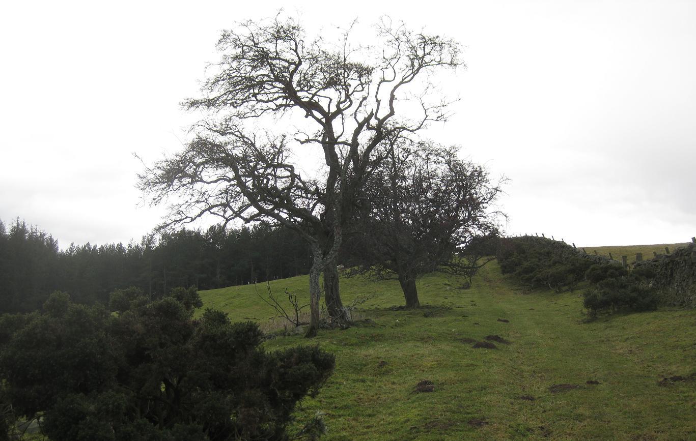
I passed the sign for a bothy (Brattleburn)- hidden somewhere up in the trees off the route I guess, then another climb up a fire break but never steep, and even with all these trees around I could sense civilisation was near. (See picture of bridge - the Southern Upland Way is the river on the left). Soon I came upon a nature-trail way-marker, then some walkers on it, then finally a carpark at the top of Crooked Road.

That section had been tougher than I thought so I was a fair bit behind schedule for meeting up with my dad at 1:30pm. I hate schedules - they should be banned at the weekend! Anyway, I picked up the pace and to be honest enjoyed doing so, it was downhill tarmac with great views over Annan Dale and Moffat. I could already hear the M74. It felt good to get past the M74, and onto a nice lane, another unexpected hillock, then some very pleasant riverside running to Drumcrieff Bridge where my dad was waiting, but thankfully not for too long as I'd arrived on time!
Flask of tea, and loads of junkfood that I could induldge in guilt-free. 20miles to go, again into new territory, and looking forward to it.

It became immediately apparent on departure that I'd been a bit greedy at the car, and my stomach was having to work as hard as my legs. It is a sustained uphill into the forested hillsides anyway, so I just settled into a slow plod for a bit.

There's a lot of forest around these parts, a lot of lonely, hilly, misty wet conifer forest. Hello, is there anybody in there? No other walkers/runners/cyclists that's for sure. The hills seemed to have huddled around me and there didn't seem an obvious way out that didn't involve a lung-busting climb.

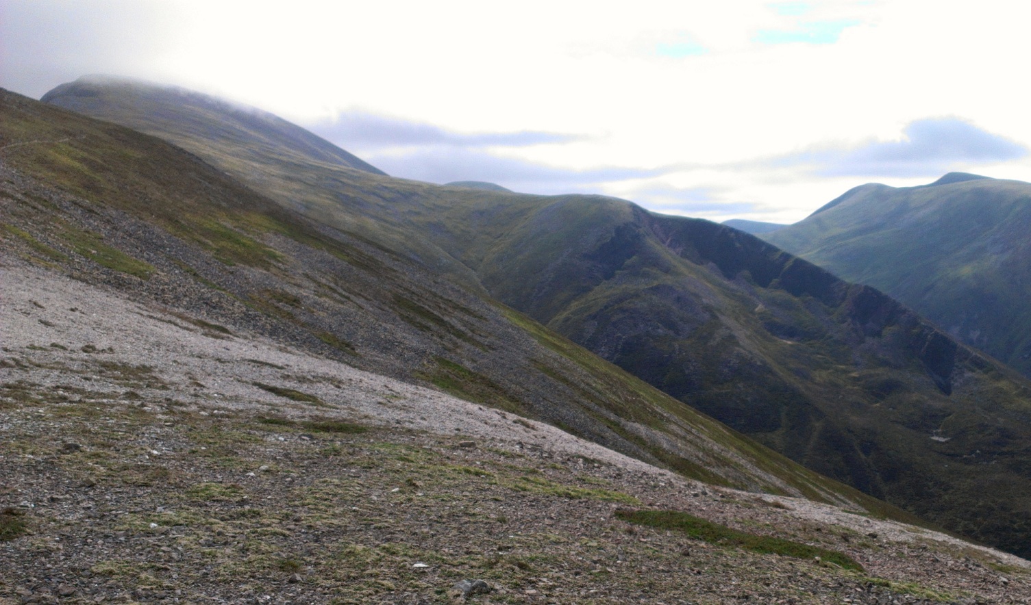
The scenery improved significantly as a waymarker put an end to the forestry road and took me onto nice grassy singletrack beside a tumbling burn, progressing out of the trees and into a wonderful den of steep hillsides at the head of Selcoth Burn. Probably my favourite part of the day's run (see title photo) it wasn't long before I was at the East/West watershed, marked by a fence, a style, and a sign welcoming me to the Scottish Borders (and Dumfries and Galloway for those heading the other direction).


Then down to another bothy, a very tidy looking and accessible bothy, before reaching the top of the tarmac road that I'd be following for about 7 miles down the glen of Ettrick Water. It was pleasant enough to run down this - probably a bit of a drag to walk - and the only car to pass me was when I was 100m from the style that would take me back Northwards up into the hills for one last time, just five miles to go to that pint by the loch.
I managed to keep a shuffling run up the steep hillside, then a nice track was reached that followed a very pleasant, gently-angled gully N towards Scabcleuch Moss (now there's a name!). With over 35 miles in the legs I had finally descended into "just get there" mode, yet I must have been paying attention because I took quite a few photos (unless they were just excuses for a rest). As usual there was one final dip and rise to negotiate before reaching the top of a dirt road that descended to the loch and the well-earned pint of Guinness.

Other Southern Upland Way Stages: Prev [1] [2] 3 [4] [5] [6] Next

Saturday, 29 January 2011

Southern Upland Way: Lauder - St. Marys Loch

Distance: 39 miles (62km) Ascent/Descent: 2200m/2100m
Start/Finish: Lauder to Tibbie Sheils Inn
Terrain:
Excellent mix with sustained high-level running on good trails, heather/grass, some forest track, some riverside/lochside, only a couple of road miles!
Transport: First Buses serves Lauder (start), Innerleithen (for Traquair, 27mile fm start), and Gala/Melrose (14/10mile fm start). No regular service for St. Mary's Loch (see note below)
Route: Route Map/Profile | Garmin Course

Southern Upland Way Stages: Prev [1] 2 [3] [4] [5] [6] Next


Summary
A delightful and again varied run with extensive views (on the right day of course). It is a long day though, so a better option (esp. if trying to use public transport) might be to finish at Traquair (27miles) and jog down to Innerleithen for a pint and a bus back to Edinburgh. That means you can come back another day by bus and run Traquair - Beatock/Moffat (regular buses both start/end).

Blog
Another perfect Winter's day for a run along the Southern Upland Way. I'm lucky in that my dad shares my passion for the outdoors, so we tend to set off on these adventures together, he'll go walking and geocaching whilst I go running, and we each have a set of keys for the car.

Today we had an early start from Lauder - the days are short at this time of year! The route climbs immediately up onto high grazing with nice views back over town. Then a more Southerly course through fields, along tracks and views of the Eildon Hills ahead.


I saw a lot of other runners this morning - certainly a great location for it. After about 8 miles of easy running the route drops down into the Tweed valley.

On reaching the river bank, the S.U.W. takes you downstream for 3/4 mile to a footbridge before returning back up the other bank beside Melrose.


Then folows some flat cycle-path running along an old railway line almost as far as Galashiels, so its almost a relief when the way markers take you up a sharp hill providing a great vantage point of the surrounding countryside (bench included!) before dropping you into the top of town.

At Galashiels I took a short detour down to a Retail Park, feeling just a tad out-of-place in my mud-caked legs, shorts and running-top walking through the isles in search of sugary food and drink. It was a nice to escape back out onto the hillsides, greeted by a few dogs and shortly after their owners, the trail then returning back down to the Tweed and crossing an old bridge before adopting a more W bearing.


The scenery continues to change, now climbing on good runnable paths into Forest and then above onto moorland, eventually climbing up to the summit of the Three Brethens. The view is worthy of the effort to get up there.


And so continues this high-level (arguably one of the best) sections of the Way, just a couple of short boggy patches but all very runnable as it gently turns by a succession of hilltops, including the shoulder of 560m Minch Moor, before descending steeply down to a carpark at Traquair.


It started to snow as I ran along the near-deserted B-road, and with only 12 miles to go I didn't mind. Fueled by smarties and pepsi I enjoyed the next section as much as the first, climbing back onto moorland and wondering which way the path would take me.


There's a long descent into forest, where I caught my first glimpse of the destination - St. Marys Loch. Having now done nearly 70miles of the Way I knew there would always be one-last-rise before any chosen destination! The route drops to a pleasant Glen/Farm setting before crossing a footbridge then climbing back up the otherside, over a wee dell, then gradually heading for the last pass of the day with St. Marys Loch now immediately afore.

I knew the final 3 miles were flat, so decided to pick the pace up and finish strong, visualizing a nice pint of beer in Tibbie Shiels, and staying the night. Neither happened as the rooms were shut for Winter renovations, what a pity!


Icy reflections on St. Mary's Loch


Southern Upland Way Stages: Prev [1] 2 [3] [4] [5] [6] Next