A runners perspective


I hope this blog is of use/interest to walkers, runners and cyclists living in or intending to visit Scotland. Most of my entries below are described as long-distance runs - just because that's currently what I enjoy doing...

Friday 12 September 2014

Grampian Weekend Day 2: Inverey to Spittal

Distance: 19.5 miles (31km) Ascent/Descent: 1000m/1020m  
Start/Finish: Inverey to Spittal o Glenshee
Terrain: 70% gravel/surfaced road, 30% Pathless 
Transport: Hmmm, tricky.  Bus to Spittal from Blairgowrie.  Bus to Braemar from Aberdeen.
Route: Route Map/Profile  
Day 2 of 2: Previous Day

Summary

A fine cross-country route from Braemar/Inverey to Spittal of Glenshee, some shameless Munro bagging involved (for the views, honest!)

 Blog

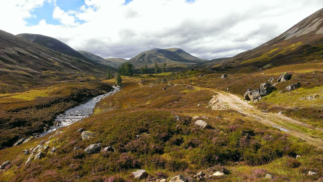
If anyone remembers the first edition of that revolution-starting book, "The Munros", there was a particular page which had always grabbed my imagination, particularly back in the days when I liked to involve the bike as a means to get to less-travelled routes up hills.  Its the page for An Socach I think, and it shows a scene of a nice flat-floored grassy glen enclosed by brown hills with a twin-rutted track winding without obsticle towards the great outdoors.  I was 16 years old when I first acknowledged it as a place I wanted to pedal through, and to this day still hadn't been there.


Looking back over Inverey to Deeside
Sunday morning in Braemar, still, grey, mild, and the nearby summits clear.  My dad and I had decided on a stroll up Glen Ey - starting at the little carpark at Inverey a few miles W of Braemar.  Finally I'd get to see and experience that place from the book, albeit by foot not mountain-bike, and by chance, within teasing reach of here was my final 'unbagged' munro in this part of the grampians!  "Carn Bhac".  I do still tick them off, more as a side-project these days.

Being the last day of August the heather was in full spendour, much of Deeside splashed with purple.  The track up Glen Ey gave easy progress from the car park and quickly we were enclosed by hills and leaving the domain of roads and cars behind.  After nearly four gentle miles we crossed a wooden-slat bridge, turned a corner and the scene got even better.  Now beneath the gable-end of Creag an Fhuathais, the grey sky submitted to a band of blue, the Ey Burn pacified into mirror-like pools breached occasionaly by trout jumping for flies, then the sun seemed to find us, there was not even a breeze, and my dad had found his slice of heaven.

"Why don't you run on to Spittal and I'll pick you up there?" he'd asked a few minutes earlier. 

My dad watches trout in the mirror-like Ey Burn
I wasn't expecting that.  It was a very tempting offer, but I'd done 25 miles at pace yesterday over the White Mounth, and other than a cheeky wee run up and down Carn Bhac, I had nothing planned for today and was't suitably equipped.  When we reached those trout pools with the sky clearing and warmth from the sun beaming down as if to pay us back for yesterday, I'd decided I'd take him up on his offer and go fo it.  Legs feeling fresh considering, the weather looked promising, I had confindence in my knowledge of the geography beyond this glen so why not?

I'm so grateful for this suggestion - within the first 500 yards of jogging up the track towards the ruined lodge at the head of the glen, my favourite tunes playing, the pace increased and I was pretty much bounding, excited by the prospect of a great journey ahead, God knows why running in these places brings so much pleasure, even in the drab conditions yesterday.  I've never quite felt the same euphoria when walking or pedalling a bike but for some reason the act of running and also having the fitness to run up pathless hillsides mile after mile is for me just the best feeling.  Especially when its a place far from the sight and noise of over-crowded places and traffic.
The flat top of Carn Bhac (looking SW to Beinn a' Ghlo)

After leaving my dad I only saw 2 couples up on the hills, and at a distance - never an encounter.  As I toiled up the gentle screes beaneath Carn Bhac's final "lump", I half expected to rise into turbulent air and need to put a jacket on.  Instead, it was calm, warm and sunny up by the cairn, and the visibility across Scotland, particularly Westwards, was magnificent.  To the SW was Carn nan Gabhar - the nearest peak of Beinn a' Ghlo - looking shapely and prominent, and to the North the Cairngorms appeared more as a single solid Plateau rather than individual mountains.  I'm so glad I came up here instead of cutting over watersheds directly to Glen Taitenaich - Munro bagging mentality has its moments.

A heavenly mile of easy running followed as I headed towards Beinn Lutharn Mhor.  Then it got messy, because the col was large and riddled with peat hags, and by the time I'd weaved and contoured around these to reach the base of the Beinn, my legs had lost their zing.  I took this as a cue to sit down amongst the heather, enjoy some water and cereal bars, soak up the sunshine for a few minutes whilst trying to pick my route up the fairly imposing wall of scree ahead of me.  One thing was decided - I wouldn't be running up it!
Looking back to Carn Bhac from B.L.Mhor
In fact it wasn't even just a walk - the ascent turned into more of a crawl, using all-fours as I took a line towards the Eastern top of the Beinn.  It wasn't quite as steep as it looked though, and gave a nice view of a lochan in the mountain's North Corrie that I hadn't known was there.

Once on the summit the running was fantastically easy - a gentle rise took me to the true summit cairn, followed by an easy descent S towards the next col where I turned more SE picking up a feint but very enjoyable deer track along the Northern contours of Mam nan Carn, and once clear of that summit I could drop down to Loch nan Eun.  I'd vague recollections of doing this particular bit before, from an epic day about 6 years ago when I'd cycled up from Blair and ran the circuit of Munros around the loch, escaping back down Glean Taitneach to get back on the bike, having a horrible "bonk" and nearly passing-out on the A93.

Loch nan Eun
My dad and I had roughly agreed to liase at the Spittal about 5pm, and although I had quite a few miles still to do they were all downhill and mostly easy, it wasn't even 2pm.  Surprisingly I had a mobile signal before dropping to the Loch so sent a message to my dad saying I'd probably be there 3:30pm.  Then I picked up the path around the loch around to where it spills into a waterfall bound for Taitneach, and once there I just sat down in the warm sunshine for a nice long break and marvelled at the landcape around, watching 100 or more deer make a rising traverse of the hillside.

Looking down Gleann Taitneach, the route off the hills to the Spittal
Gleann Taitneach is a fine place to linger, but today I was really enjoying my running and so refreshed from the break I made my way very quickly down the track for several miles to the Spittal of Glenshee.  Presently here was the saddening sight of the recently burned-down Spittal Hotel.  Many happy memories have either started or finished in that place.

Previous Day

Grampian Weekend Day 1: Lochnagar and Glen Muick

Distance: 24.7 miles (40km) Ascent/Descent: 1110m/1250m 
Start/Finish: Braemar to Ballater Terrain: 75% gravel/surfaced road, 25% Good high-elevation trail Transport: Good Stagecoach bus service between Braemar & Ballater 
Route: Route Map/Profile
Day 1 of 2: Next Day


Summary
 
A great non-technical cross-country route from Braemar to Ballater via Lochnagar and Glen Muick. Relative to other blog entries this was a very short day, in fact less than 3 hours 50 for me as I treated it as a workout at times! But if you look at the profile there's not much up and down other than the initial up and final down, and its all so runnable. Having said that, a fair amount of time is spent 1000m up on an exposed plateau, no place to crock an ankle, so carrying emergency clothes/blanket is common sense (as is "just taking the bus instead" for some).

Blog

I've never been a fan of the phase "there's no such thing as bad weather, just bad clothing". Fair enough for a survivalist. But generally I'm out on the hills by choice, and when you can't see shit and your picnic's soggy a multitude of breathable layers doesn't turn the sky blue. However, this is not a moan about how I spent 8 miles around 1000m+ on the White Mounth wishing it would clear up so I could see fantastic views over the Grampians, Cairngorms and down into Deeside. I'd been up here and seen it before, allbeit 20 years ago. Today I had a blast along an excellent and relatively easy trail with a sharp wind helping me along, and the weather just added to the sense of wildness and probably kept Lochnagar relatively peaceful for a weekend in August. Me & my dad were up in Braemar - he was looking to do a walk around Ballater as he hasn't done much over that way before. So I settled for running there, wherever he'd parked the car, and do a jolly cruise of Lochnagar and Glen Muick.

Looking back towards Braemar from the start of Glen Callater
During a break in the rain, and starting from outside the Fife Arms Hotel, I headed up the single-track road past the golf course, retracing the route I did when going Blairgowrie to Braemar via Jocks Road - finishing in darkness! Today I almost missed the little bridge over the River Cluanie after a couple miles, already in a running trance! Once found, the bridge let me get over to the base of the landy track up to Loch Callater. I reminisced about the last time I'd been here when it was Winter and dusk, and I remembered how much I'd enjoyed that. Today it was nice in a different way - seeing it in daylight, even with the rain starting to build up again, the sun made an effort and cast a low rainbow in the glen behind me. On approaching the loch I should have continued through the gate past the lodge to pick up the path to the White Mounth, instead I continued on to the shore, a nice enough detour, but it did mean a tough heather-avoiding ascent straight up the hillside to get myself on the path again which seemed to have already gained a fair bit of height where I finally joined it.

Looking over Loch Callater towards line of Jock's Road
From here it was easy angled on a well-maintained trail but lots of boulders on it to keep the eyes from looking at the view over the loch. The path curves away from the glen, dipping momentarily before starting to climb onto the Mounth proper. So I layered up a bit, gloves and hat went on, then proceeded to enter the clouds. After a few minutes and on reaching a stone-wall with rusty fence posts, I left the path to reach the summit of Carn an t-Sagairt Mòr, a fairly pointless exercise in these conditions other than an easy summit to bag since the path went so close.

Looking back down the contouring trail (L. Callater hidden below)

I got the full brunt of the wind up on the top, thankfully blowing from the side, but it meant running with one eye as I headed down the other side to find my path again. A mountain-bike-pusher appeared from the mist ahead, he was bent into the wind and probably about ready for a nice landrover track by now. I briefly dropped into a hole in the clouds before rising back up onto the plateau proper, gradients remaining easy until a final but brief pull up Lochnagar to Cac Carn Mòr, then its a case of turning more N to reach the marginally higher summit of Cac Carn Beag and its trig-point-topped Tor. Enroute to this I played chicken with a charging black lab, it wanted to join me on my run back off this soggy windswept lump.

More cheek-freezing wind as I retraced a route back to the larger cairn and then beyond to continue SE then E over the plateau, tracing the edge of the cliffs on a good path which after a mile dropped fantastically down the large scree, slab-by-slab, out of the cloud and back to a more friendly-looking world lit with patches of sun. The loch of "Lochnagar" was now visible to the left and an impressively conical lump ahead which I couldn't be arsed climbing. I was soon "layering-down" to a T-shirt again, picking up a landrover track that rises up from the top of Glen Muick.

Dropping quickly from Lochnagar via a dirt road
From here it was an easy and very fast run NE down the glen along an excellent car-free track, just a couple miles of road at the end before arriving at Ballater feeling invigorated. My dad had come off the hill only 30minutes before, having had a soaking up the hills followed by a cup of tea and scone. The weather forecast promised better for tomorrow, so we decided we'd maybe do a walk...

A fine cycling/running track down the length of Glen Muick
Next Day (Sunday)