Distance: 30 miles (48km) Ascent/Descent: 1300m/1300m
Start/Finish: Tillicoultry, Dollar, Blackford or Auchterarder
Terrain: Mostly good, runnable hill tracks (steeper on Southern aspects), some back roads and farm tracks
Transport: Buses connect Blackford/Auchterarder with Stirling/Perth. Buses connect Tillicoultry/Dollar with Stirling/Cupar.
Route: Route Map (and GPX)
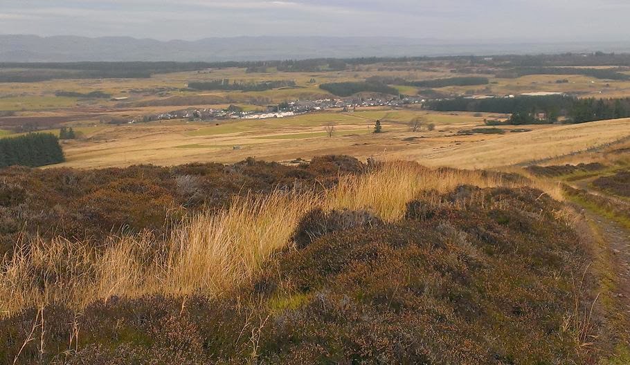
 |
| The Ochils seen from the "Devon Way" (Old railway route) |
|
Summary
Again I'm probably guilty of overlooking the Ochils because they're so close. How stupid. The Glens above the Hillfoot towns are gorgeous, sure, but that's where I always seem to end up when I do go for a run here. I've never explored the Northern aspects of this range. The relatively lower altitude of these hills and surrounding area also means they're more likely to be accessible in Winter. This loop traverses the Ochils twice using historical routes - Tillicoultry to Blackford and Auchterarder to Glendevon then to Dollar. And between the hill running you get to run a few miles in both the Forth Valley and Strathallan! I did it clockwise starting from Tillicoultry, although I was looking over my shoulder a lot and thinking anti-clockwise could be nice too.
 |
| Out onto the hills above Tillicoultry (the route heads high-up to L of lump shown) |
Blog
 |
| Looking towards the Forth from above Mill Glen |
Starting from Tilly (I parked on one of the back streets near Upper Mill St.), I headed up towards Mill Glen, but instead of going into the glen I took the path up to the right which climbs higher up the hillside parallel to the Glen (the Glen's nice though and if you've not been there before its worth taking that route instead, as far as the bridge at the confluence of the Daiglen/Gannel burns, then instead of crossing the bridge, double back steeply up the rocks (South), and after a few minutes keep looking left for a steep, rough track through bracken to gain the true route to Blackford).
 |
| A nice view of the "wrong way" - Daiglen Burn |
The "actual" route climbs up out of the trees and through a gate into gorse and open hillside (picture above), the good path continues zig-zagging upwards. Be warned that higher up its easy to get routed to the left along a more level, obvious path, this swings back towards the glen and ends up at the bridge mentioned above. That's exactly what happened to me, not for the first time! The "actual" route keeps climbing, swinging around a rocky "nose" to head NE to reach a watershed between Andrew Gannel Hill and Kings Seat.
 |
| Ascending to the col between Andrew Gannel Hill (L) and Kings Seat |
 |
| Looking N from above the watershed on Skythorn |
From the watershed, continue up the (initially steep) track towards Andrew Gannel Hill for about 70m, but look out for a feinter track contouring off to the N towards what looks like a couple of rocks. This ends up following a fence, negotiating a couple of deep dells, otherwise climbing gently to a gate at the col a little shy of 600m, from where you enjoy two very different aspects of Scotland. Its also quite exposed (Ben Cleuch and surrounding area has a reputation for being ridiculously windy) - my hands were quickly becoming numb and I was wishing I had mits instead of gloves. Nevermind, all was good because I was about to enter unfamiliar territory...
 |
| Grodwell and Gloich Glens, Ben Cleuch (highest point in Ochils) beyond |
The way ahead becomes more obvious, a grassy (or icy!) track, which keeps high on the ridge above the remote Broich Burn. Eventually it drops down towards the Glendevon Reservoir where a fairly industrial looking bridge forms part of a new access road up to the wind-farm on Burnfoot Hill. Take the track briefly until below the farm buildings (Blackhills), where a sign directs the walker/runner N into bog.
 |
| Trees and stile to aim for when following shore of Upper Glendevon Resr. |
And over a fence. Aim for the "plantation" just above the reservoir, there's a stile over a fence into the trees, after which a muddy and very steep path crosses the steep dell of Muckle Burn, leading to another stile, and a rare waymarker post. The path continues slightly downhill and heading away from the shore, reaching a gate at the corner of a field (a field only because of the fence around it!).
 |
| A useful clue for route-finding (R. Devon above Reservior) |
Continue WNW, arriving at some peat hags (I lost the path here but found it again a bit closer to the water - by the fence).
The path leads up the W arm of the reservior eventually crossing the River Devon by a narow bridge. The glen ahead looks inviting (there's a waterfall a few hundred metres beyond the bridge), but the way to Blackford requires doubling-back along the N shore of the reservior following a fence, eventually swinging away to visit some ruins.
From the ruins, narrow paths lead NW into the tiny "Glen Bee", arriving at a stile. There seems to be a choice of paths from here, I took the easier option keeping lower in the glen, eventually arriving at the last col of the traverse where the path joins a wide gravel track, and a fantastic view opens out over Strathallan and Strathearn, the Highlands teasingly close by.
 |
| View over Strathallan with Ben Vorlich and Stuc a' Chroin on the skyline |
 |
| Descending towards Blackford |
Its an enjoyable, easy downhill run from here along the track above Glen Kinpauch, which swings around Kinpauch Hill and descends into Blackford. The A9 has to be negotiated first, of course - turn left on reaching the parallel road, and then after a couple hundred metres its time to say your prayers and play real-life "Frogger", hopefully arriving into the village beside the retail outlet.
There's a wee shop in town where I picked up some much-appreciated junk food.

The next section of the route is a bit different - now out of the Ochils, follow the B8081 over the rail-crossing, continue around the bends for 500m until just beyond a junction and farmhouse there's a right-of-way sign pointing into a field on the left, from where a good, peaceful track leads up alongside old oak trees, beside horses and after a mile you enter Gleneagles Golf Course! Way-markers take you from here safely between the fairways, the club house and hotel visible to the left, bringing you out by a carpark adjacent to the A823. Head N along this briefly, then fork R towards Auchterarder - one of Scoltand's "Lang Toons" (and another chance to get refreshments).
 |
| Climbing back into the hills (Cloan Glen) - the start of "Cadgers' Yett" |
Its now time to get back into the hills. I headed almost to the end of the village, taking a right (Abbey Road) down into "Milton" then back over the A9 to a junction, turning R (West) for 300m to gain the start of the minor road that climbs S into Cloan Glen. This is the start of "Cadgers' Yett" - the historical through-route from Auchterader to Glendevon. It may start as a tarmac road but there's no doubting its a slog - especially on rapidly-tiring legs. I made use of the views back North justify a few cheeky rest-stops.
 |
| Coul Burn, above Coulshill Fm |
The road does level eventually, into forest then out again, undulating towards Coulshill Farm. Instead of entering the farm, continue ahead on the sign-posted track up the glen through open hillside, keeping to the R of the Coul Burn. After a mile the track swings up to the R, at first ascending towards the windfarm. Its no worse going than the tarmac at the start, and eventually arrives at the high-point of the pass at a stile with the noisy wind turbines nearby on the R. The Forth Valley comes back into view.
This is my first long outing for a while so I was feeling it a bit here, but still quite content because I'd made good time and knew it is mostly downhill from here back to Tillicoultry. Mostly!
On reaching the A823 road, turn L for 100m then look for the "footpath
to Dollar" sign pointing R. This path crosses the River Devon, climbs
up to a lovely old bridge (which you cross), and another sign points the
way up the hillside towards Glenquey Reservior. There's some nice,
native woodland planted on the slopes of Innerdownie Hill to the N here.
The path is steep at first but quickly levels out, follows the shore
of the reservior, then climbs beyond into a dell before dropping down
through a currently-felled plantation and arriving at the road to Castle
Campbell above Dollar.
 |
| Descending Borland Glen towards Glendevon Village |
 |
| Glenquey Reservior |
To descend into the Glen (recommended if the area is new to you) head R steeply down towards the castle to pick up the top of the walk that will take you down by the burn into Dollar. I took the easy option of just following the road back into town. Whichever option you chose, stick to the burn-side on reaching town, following it downstream on the W side to the bottom, then cut R on the short path into Strathdevon Place, from where access down onto the Railway-path should be obvious, via the old station platform! Here follows the easiest 3 miles of the day, which is probably why I'm glad I started the circuit where I did. Old railways can be boring but this one has plenty interest thanks to the Ochils rising to the R (title picture), and frequent rendezvous with the River Devon. The railway path enters Tillicoultry near the Sterling Mills retail park.


 The next section of the route is a bit different - now out of the Ochils, follow the B8081 over the rail-crossing, continue around the bends for 500m until just beyond a junction and farmhouse there's a right-of-way sign pointing into a field on the left, from where a good, peaceful track leads up alongside old oak trees, beside horses and after a mile you enter Gleneagles Golf Course! Way-markers take you from here safely between the fairways, the club house and hotel visible to the left, bringing you out by a carpark adjacent to the A823. Head N along this briefly, then fork R towards Auchterarder - one of Scoltand's "Lang Toons" (and another chance to get refreshments).


Hi Scott, just came across your blog. You're right the Ochils are often overlooked but a quick day out from the city and some good leg work up those steep climbs. I'll dip into your older stories. Was interested that you'd cyled across the USA which I also did a couple of years ago. Pauline, www.theoutdoordiaries.blogspot.com.
ReplyDeleteYep that bike trip across USA/Canada was amazing, we're so lucky to have done that and have the memories. Hard to believe that was over 8 years ago for me now (and the bike's hardly moved since!). Lovely photos by the way :-)
Delete