Ascent/Descent: 1670m/1670m
Start/Finish: Blair Atholl
Terrain: 45% gravel, 40% Hill tracks, 15% road.
Remote moorland but generally dry/firm underfoot
Transport: train station and citylink bus services Blair Atholl
Route: Route Map
 |
| Lower Glen Tilt |
Summary
Glen Tilt is bicycle-heaven. It forms a great through-route from Blair Atholl to Deeside which I used many years ago as a student when cycling from Fife to Aberdeen! It also makes for easy walking/running acess into (or out of) stunning remote country. Next to Glen Tilt but generally hidden from view are the broad rounded heather-clad lumps of Beinn a' Ghlo, which boasts three Munros. This route takes in the summits of the Beinn first, then gives the tired legs an easy trot back down Glen Tilt. Once onto the first summit of Carn Liath, the gradients are generally gentle and the cols are shallow which makes it all very runnable. There are great views over high moorland to the Cairngorms, but my favourite view is from the descent down into Glen Tilt.
Blog
With less than 2 weeks until the Grand Raid des Pyrenees, and only 2 weeks since enjoying a fantastic run at the Lakeland 100 race, I chose this run as a way of keeping the fitness ticking over, hoping not to do any damage to muscles that were still in recovery mode. (My original plan for this loop was to return via Carn a' Chlamain - a Munro on the NW side of the Glen. This adds 4 miles and 650m ascent.)
 |
| Memorial Stone - Carn Liath rising beyond |
Beyond the old bridge over the River Tilt, a single-track road leads E up to Loch Moraig, making relatively easy work of the first 200m of today's ascent. (There's a small car park up here - full by the time I was jogging past after midday).
A gravel track branches off to the NE, the gradient remaining gentle, then after a mile of this it was time to start climbing proper, forking N over a small crest, past a couple of huts, and once through one of the only areas of bog I'd encounter today.
 |
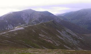
| Braigh Coire Chruinn-bhalgain (1070m), with Carn nan Gabhar to R (1129m) |
Some more "snaking" E then N along increasingly rocky and broadening ridge before the next summit is reached. Already there's only one significant climb left for the day, which suited my still-recovering legs just fine! The cloud lifted again and I could see far into the remote country to the NE - basking in sunshine - with the Cairngorms clearly visible beyond.
 |
| Looking from Airgoid Beinn SW back over Carn Liath |
 | |
| Looking back S towards Carn nan Gabhar |
The sun was really shining, the jacket was off again, a feeling of being on-top-of-the-world, happy days!
 |
| Descending through the heather towards the beautiful Glen Tilt |
 |
| Dail Feannach above Glen Tilt |
 |
| Looking down Glen Tilt, 9 downhill miles to go! |
 |
| A great place to fill the bottles |
After enjoying the sunshine for a moment, sitting by the cascade and re-filling the bottles, it was time to pick up the pace down the easy track. The sunshine was such a bonus - it hadn't been forecast! And it was very warm too. There were a few mountain-bikes chained to fences along the glen, which makes a lot of sense for exploring the hills around here.
With only 4 miles to go the glen begins to twist and drop a little steeper. There is a final short rise to overcome before arriving at the Old Bridge of Tilt, from where the route rejoins the first outward mile. A great accessible day out.