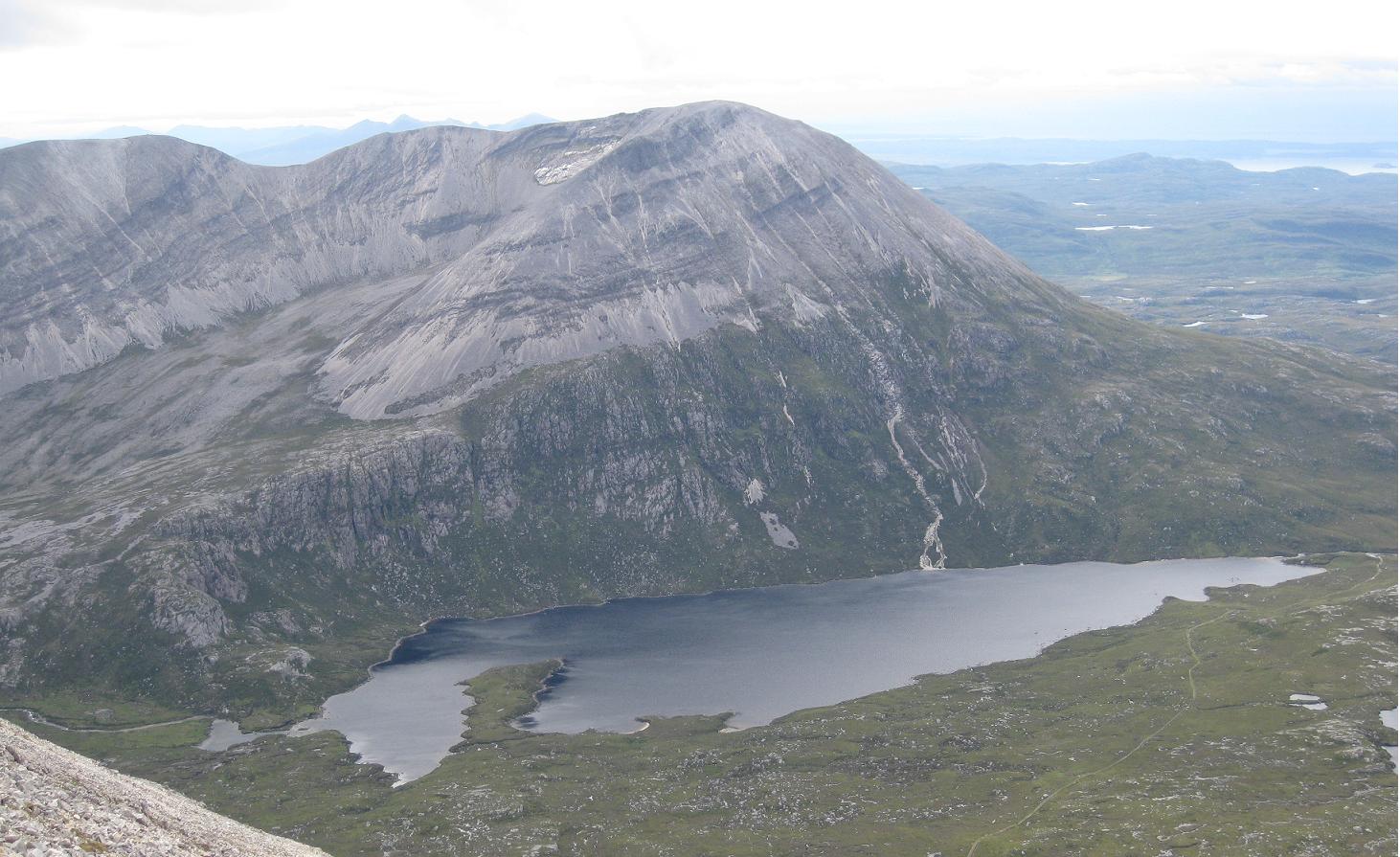
Distance: 18.5 miles (29.5km) Ascent/Descent: 1650m/1510m
Start/Finish: Loch Stack Lodge to Gualin House Terrain: 30% Good track, 60% Wild, rough, 10% scree/rock
Transport: Car + bikes to get back to car!
Route: Route Map | Garmin Course [coming soon]
Summary
Hidden in the far North West of Scotland are these gems of mountains, modest in height but bold in every other sense. As if the mountains themselves aren't enough, the corries and glens around them are stunningly wild, and a network of trails penetrate the region offering lots of possibilities. The route described here is a summit traverse, but there is so much here that warrants another visit or two, and that's taking into account its isolated location! From the rocky summit ridges, the views over the rugged surroundings are very special, and on the right day stretch over the Minch to the Isle of Lewis. The traverse of these "Corbetts" is a fine, serious day's expedition on the mountains, but requires leaving bicycles at one end to get back to the car at the start (or if you're lucky like me, a helpful support-driver, just be prepared to buy them plenty pints and a dinner in return!) If using bikes I reckon leaving them at the NW end (Gualain House) as its mostly a downhill ride back to Loch Stack Lodge. And no, unlike most of my other entries, this isn't all runnable!
Blog
I wouldn't have attempted this on a poor weather day. Firstly it would be shame to miss out on the reason I was doing it - the views - but additionally I was out on my own (I didn't meet anyone else on Foinaven) and I'd read it could be quite easy for things to go wrong on a bad day. Looking back, I'm especially thinking about part of the ridge of Foinaven, which takes a bit of care when descending and I can imagine I'd have felt a little less "happy" had the rock been wet, the wind blowing hard, and the cloud obscuring an otherwise obvious route down.
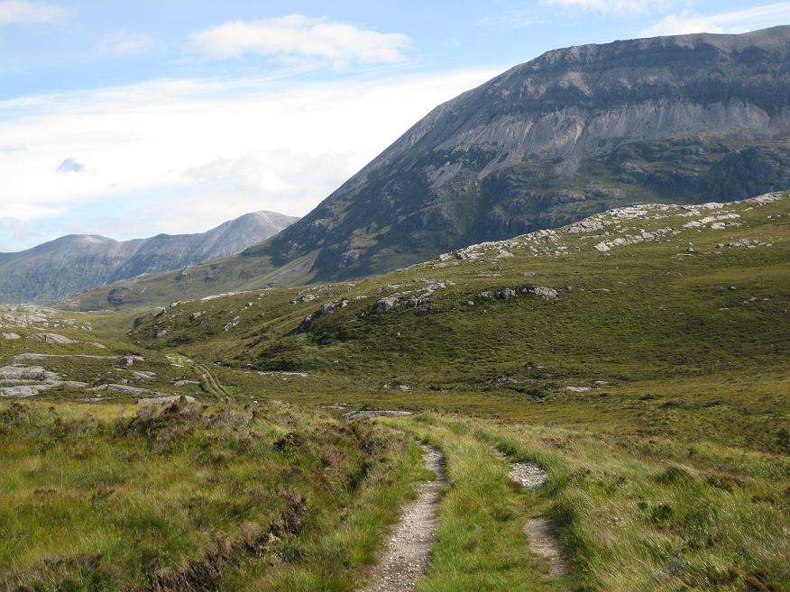
From Loch Stack a really good (and cyclable) stalkers path takes one right into the middle of the Foinaven-Arkle country. As I jogged up this, Arkle was there somewhat intimidatingly ahead. The track swings around its Western flank and climbs gently to a high-point, with Foinaven coming into view. That's when I struck SE on ever-steepening ground that looked rougher and boggier than it was. The hillside ahead looked impossibly steep, but it must have been an illusion because the large scree boulders were mostly stable and walkable (no I'm not running at this point!).
I was soon on the summit and took a moment to admire the view over to Foinaven, and of Arkles' other summit, before starting to run along a nice narrow ridge that reminded me a bit of the Carn Mor Dearg Arete as it arced around. Once on the lower summit I started heading SE again, picking the easiest route I could find through the boulders, and around to Lochan na Fabileige, which is perched on a ridge and looks like it might spill into the glen below on a really windy day!
From there it was a rough descent ENE into a peat hags (I probably could have taken a better line sticking to the rocky slabs just to my SE) beyond which I picked up another brilliant landy track. I ran up this and onto the featureless grassy shoulder of Foinaven at Bealach Horn. The views back to Arkle were great, with its folds of bare rock. I returned to a walk now, drawn naturally to the crest of the SSW ridge so I was looking across Coir' a' Chruitier to my eventual onward route over Foinaven - but first I had to circle around the Coire.
Once this was done, and on the 808m peak, the true character of Foinaven was presented, and it started with a steep rocky descent that thankfully looked trickier than it was. Further down was the true test of the day - again everything's fine on a nice day and you take your time. The situation at this point is fantastic, with Foinaven's ridge rising impressively infront and behind, the view of Arkle across the loch directly below, and in the other direction, another ridge of this complex mountain, A' Cheir Ghorm (supposed to be a great ascent route too!) with its wall of orange scree running inwards to join the ridge ahead.Continuing along the ridge, bypassing the impressive tower of rock, the route is more straightforward and views of the ocean open up again.
I visited both summits of Ganu Mor then my chosen route ignores the final peak to go exploring one of the many corries - Coire Duail. Before descending NE I managed to make radio contact (walkie-talkies!) with my dad who had just parked up at Gaulin House and was going to start making his way up the new landy road into the valley below. It's always a relief to make that first contact!
Traces of path can be seen on the scree ridge heading down, and once onto the wild craggy ground above the E wall of the Coire, there are the odd traces of boggy path again where deer and walkers have been funneled between the outcrops. I picked up the course of the burn that marks an easy way down N into the Coire and its Lochan, taking a last glance at A Cheir Ghorm behind me, and noting the vivid contrast between where I was now and where I'd been.
I put myself on the N side of the burn as soon as feasible and cut the corner slightly lower down to reach the Allt Coire Duail. It wasn't obvious where to cross the fast-flowing water but as I headed a little downstream there was an obvious safe place to jump the big rocks and so I attained a bit of a path on the N bank. When this petered out I just cut across country NNE out of the jaws of the Corrie and picked up the landy track which was followed for 4 miles up to the road, during which I met 2 of the only 4 walkers I'd encountered today. Having lost a bit of fitness lately I didn't have the endurance to run this, so it was a power-walk, but I was so happy with my day I didn't mind it. We got back to Durness campsite which had been home for the last couple of days and was home for the next couple of days. A fantastic area to spend a long weekend camping and exploring.
A runners perspective
I hope this blog is of use/interest to walkers, runners and cyclists living in or intending to visit Scotland. Most of my entries below are described as long-distance runs - just because that's currently what I enjoy doing...
Showing posts with label highlands. Show all posts
Friday, 12 August 2011
Foinaven & Arkle Traverse
Monday, 16 May 2011
Anoach & Rannoch
Distance: 28 miles (45km) Ascent/Descent: 1820m/1870m
Start/Finish: Dalwhinnie to Rannoch Stn
Terrain: 40% gravel/surfaced road, 30% hillside, 30% ridge-top trails
Transport: train stations at start/end. citylink bus services both places
Route: Route Map | Garmin Course
Summary
One of my first ever "ultra-distance" runs was from Dalwhinnie to Ft. William - accompanied by a chap Mike Thompson as part of our training for the West Highland Way race back in November 2008 (see photo below). And what a fantastic introduction to long distance routes - from the very remote Ben Alder Forest to the much more populous but very scenic Glen Nevis. The route described in my blog below follows the same good track as far as Loch Pattack, but for added stupidity I took in the "Anoach Four" ridge of Munros to the North of the Bealach Dubh, dropped down to the Bealach then went Munro bagging again on my way down to Rannoch. The sensible way is of course to camp or stay in Culra Bothy or Ben Alder Cottage en-route. And/or use a bicycle.
Blog
Again I was teamed up with my dad for another weekend of outdoorsy madness. We drove to Pitlochry Station with unstable clouds above, as forecast, but the day promised to deliver fine views when you weren't up in the clouds, or getting soaked by every kind of precipitation known to man.
Nice to meet cyclists and other walkers waiting for the train. My dad was driving off to a point near Rannoch Station, he was doing his first "Solo" climb of a Munro for years (Carn Dearg) and I was hoping to catch up with him much later on during his descent, all things going well. We had a walkie-talkie each.
I was a bit confused on disembarking the train at Dalwhinnie as the sun was shining - that's not what usually happens here. Jogging back over the railway tracks and onto the NW shore of Loch Ericht, I got the much-anticipated feeling of "heading out into the wilds", and it felt damn good. Of course, the estate landy track is very much a road these days so its hardly wild at all - but as you walk, pedal or in my case run down it, you know that the place it takes you is very remote and embraced by some fine mountains and corries.
The track eventually (6-7miles) climbs gently away from the loch then descends towards Loch Pattack - those not heading for the Anoach Ridge would most likely turn-off the path onto a lesser track directly towards Culra Bothy and the wonderful Bealach Dubh beyond.
As I passed the curious estate ponies, I noticed the hillside beyond Loch Pattack became psychedelic. I was looking through a very low-angled rainbow - lots of sunny rain going on today.
Its little credit to the imagination of those tasked with naming Scottish mountains that both my first and last hill of the day were "Carn Deargs". Red Hill. My route choice onto the ridge of Carn Dearg No. 1 was a tad unorthodox (if orthodox is defined by the SMC books or munro-bagging websites), in that I decided to abandon the track at the top of Loch Pattack and pick my way up through the heather, moving from one burn to the next trying to find the easiest ground. This worked out ok as the going wasn't too steep until higher-up, by which point I was on exposed, windclipped terrain and knew I could look forward to much easier running from then on! In theory. In practise, it was me who got windclipped, and I was very quickly putting on hat, gloves, and after spinning around like a dog chasing its tail I finally got my other arm into the goretex too. The mountain forecast had warned of extreme gales and severe windchill, and snow on the summits, and possible thunderstorms, and for the likes of me and my dad the intent of such warnings never fully sink in until we're sober and 850m up a 1100m mountain and unable to individually move our fingers. The cloud was rushing past just metres above my hood. Was I still having fun? Not as much as I had been earlier, due to a bit of dread about trying to run into that cold gale along a high-altitude ridge for the next 5 miles. I soon cheered back up again, because after ascending into the cloud, picking up traces of Munro-baggers path, then cresting the boulder-strewn summit of Carn Dearg, the cloud lifted to reveal a stunning view of Lancet Edge and Ben Alder's Short and Long Leachas, all in partial sunshine (title photo). Even the conical Schiehallion could be seen, and later today the knobbles of Glencoe - visibility was excellent between the clouds and the squalls. (Hint: Don't look for the knobbles of Glencoe on a map).
I was grateful for the shelter afforded by the mass of Gael Charn ahead, so I stopped and admired the situation and enjoyed feeling my fingers again. Loch an Sgoir beneath me, Lancet Edge beyond, Long Leachas beyond that.
My route ahead looked inspiring, with a narrow waterfall cutting its way down the cliff to the left like a strike of lightening, two lochan-filled corries glimmering beneath me, one to each side, and a stony ridge ahead which I was chuffed to manage to run up without resorting to a walk. Just before I was back in the cloud I could see I was now above Lancet edge, and level with the banks of old snow. Very quickly I was upon the plateau, and glad to let the Garmin keep me on a bearing straight for the summit cairn about 1/2 mile away, surrounded by small drifts of fresh snow at 1132m.
Again the cloud was kind enough to lift briefly for me, and I could see Anoach Beag ahead, and Beinn Eibhinn beyond. Fortunately the uphill bits were sheltered from that wind so it wasn't as tough as I feared, and I was getting a lot more views and sunshine than I'd expected today.
I got briefly disorientated on descending Beinn Eibhinn in cloud as the ridge curves subtly Northwards and although I'd cut off to the left I was actually still running more W, not S like I imagined. My excuse is I was too busy picking my way through the boulders! But at least I got an unexpected view of forest above Fersit and the reservior once beneath the cloud, which fortunately I recognised as not being Loch Ossian! I corrected my course, apologised to my garmin for ignoring it and descended rapidly into much warmer climes of the Uisge Labhair glen. I took an overdue drink from a burn and refilled the hydration bladder from it, along with a Nuun tablet. Got down to the river, decided the best way across was to get wet feet so just waded through it then started piking my way S and SW up the hellishly heathery slopes of Sgor Choinnich. Bad route choice. I was heather bashing, and after 21miles of running I no longer had the strength to keep it going so was reduced to a walk-jog-gasp-look-at-the-scenery-a-lot-more method of progress. Once back onto the windclipped higher hillside (and putting the goretex back on as the rain came down) I was able to get into a shuffling jog again but it wasn't as enjoyable as before - I was burning fat now, and last night's bottle of Leffe. I could see Carn Dearg No. 2 in the distance. Walkie talkies work best with line-of-sight so I decided to try make contact with me dad. Contact made - he was sheltering at the summit cairn, good on him! He was also cold so he said he'd start his descent back S along the ridge towards the car parked at the base of "the Road to the Isles". It was re-assuring to make that contact though, and know we were both okay.
Briefly back into cloud for the last time, I ascended the "top" of Sgor Chonnich then took a run at the shapely Sgor Gaibhre, reaching the top with relief rather than elation.
Certainly felt good to be stretching the stride back out down the other side, W towards Mam Ban (thank you Wham). Rain showers, still accompanied by sunshine, now turned to hail as I made my way onwards to Carn Dearg No. 2 where my dad had been radioed earlier.
The hail passed and it was much nicer to us from then on. I made good progress down the ridge and soon caught up with my dad, who seemed to have taken my hip injury off me. We made our way safely off the hill from there after a very long, testing, but satisfyingly adventurous day out in the Scottish wilds.
Start/Finish: Dalwhinnie to Rannoch Stn
Terrain: 40% gravel/surfaced road, 30% hillside, 30% ridge-top trails
Transport: train stations at start/end. citylink bus services both places
Route: Route Map | Garmin Course
Summary
One of my first ever "ultra-distance" runs was from Dalwhinnie to Ft. William - accompanied by a chap Mike Thompson as part of our training for the West Highland Way race back in November 2008 (see photo below). And what a fantastic introduction to long distance routes - from the very remote Ben Alder Forest to the much more populous but very scenic Glen Nevis. The route described in my blog below follows the same good track as far as Loch Pattack, but for added stupidity I took in the "Anoach Four" ridge of Munros to the North of the Bealach Dubh, dropped down to the Bealach then went Munro bagging again on my way down to Rannoch. The sensible way is of course to camp or stay in Culra Bothy or Ben Alder Cottage en-route. And/or use a bicycle.
Blog
Again I was teamed up with my dad for another weekend of outdoorsy madness. We drove to Pitlochry Station with unstable clouds above, as forecast, but the day promised to deliver fine views when you weren't up in the clouds, or getting soaked by every kind of precipitation known to man.
Nice to meet cyclists and other walkers waiting for the train. My dad was driving off to a point near Rannoch Station, he was doing his first "Solo" climb of a Munro for years (Carn Dearg) and I was hoping to catch up with him much later on during his descent, all things going well. We had a walkie-talkie each.
I was a bit confused on disembarking the train at Dalwhinnie as the sun was shining - that's not what usually happens here. Jogging back over the railway tracks and onto the NW shore of Loch Ericht, I got the much-anticipated feeling of "heading out into the wilds", and it felt damn good. Of course, the estate landy track is very much a road these days so its hardly wild at all - but as you walk, pedal or in my case run down it, you know that the place it takes you is very remote and embraced by some fine mountains and corries.
The track eventually (6-7miles) climbs gently away from the loch then descends towards Loch Pattack - those not heading for the Anoach Ridge would most likely turn-off the path onto a lesser track directly towards Culra Bothy and the wonderful Bealach Dubh beyond.
As I passed the curious estate ponies, I noticed the hillside beyond Loch Pattack became psychedelic. I was looking through a very low-angled rainbow - lots of sunny rain going on today.
Its little credit to the imagination of those tasked with naming Scottish mountains that both my first and last hill of the day were "Carn Deargs". Red Hill. My route choice onto the ridge of Carn Dearg No. 1 was a tad unorthodox (if orthodox is defined by the SMC books or munro-bagging websites), in that I decided to abandon the track at the top of Loch Pattack and pick my way up through the heather, moving from one burn to the next trying to find the easiest ground. This worked out ok as the going wasn't too steep until higher-up, by which point I was on exposed, windclipped terrain and knew I could look forward to much easier running from then on! In theory. In practise, it was me who got windclipped, and I was very quickly putting on hat, gloves, and after spinning around like a dog chasing its tail I finally got my other arm into the goretex too. The mountain forecast had warned of extreme gales and severe windchill, and snow on the summits, and possible thunderstorms, and for the likes of me and my dad the intent of such warnings never fully sink in until we're sober and 850m up a 1100m mountain and unable to individually move our fingers. The cloud was rushing past just metres above my hood. Was I still having fun? Not as much as I had been earlier, due to a bit of dread about trying to run into that cold gale along a high-altitude ridge for the next 5 miles. I soon cheered back up again, because after ascending into the cloud, picking up traces of Munro-baggers path, then cresting the boulder-strewn summit of Carn Dearg, the cloud lifted to reveal a stunning view of Lancet Edge and Ben Alder's Short and Long Leachas, all in partial sunshine (title photo). Even the conical Schiehallion could be seen, and later today the knobbles of Glencoe - visibility was excellent between the clouds and the squalls. (Hint: Don't look for the knobbles of Glencoe on a map).
I was grateful for the shelter afforded by the mass of Gael Charn ahead, so I stopped and admired the situation and enjoyed feeling my fingers again. Loch an Sgoir beneath me, Lancet Edge beyond, Long Leachas beyond that.
My route ahead looked inspiring, with a narrow waterfall cutting its way down the cliff to the left like a strike of lightening, two lochan-filled corries glimmering beneath me, one to each side, and a stony ridge ahead which I was chuffed to manage to run up without resorting to a walk. Just before I was back in the cloud I could see I was now above Lancet edge, and level with the banks of old snow. Very quickly I was upon the plateau, and glad to let the Garmin keep me on a bearing straight for the summit cairn about 1/2 mile away, surrounded by small drifts of fresh snow at 1132m.
Again the cloud was kind enough to lift briefly for me, and I could see Anoach Beag ahead, and Beinn Eibhinn beyond. Fortunately the uphill bits were sheltered from that wind so it wasn't as tough as I feared, and I was getting a lot more views and sunshine than I'd expected today.
I got briefly disorientated on descending Beinn Eibhinn in cloud as the ridge curves subtly Northwards and although I'd cut off to the left I was actually still running more W, not S like I imagined. My excuse is I was too busy picking my way through the boulders! But at least I got an unexpected view of forest above Fersit and the reservior once beneath the cloud, which fortunately I recognised as not being Loch Ossian! I corrected my course, apologised to my garmin for ignoring it and descended rapidly into much warmer climes of the Uisge Labhair glen. I took an overdue drink from a burn and refilled the hydration bladder from it, along with a Nuun tablet. Got down to the river, decided the best way across was to get wet feet so just waded through it then started piking my way S and SW up the hellishly heathery slopes of Sgor Choinnich. Bad route choice. I was heather bashing, and after 21miles of running I no longer had the strength to keep it going so was reduced to a walk-jog-gasp-look-at-the-scenery-a-lot-more method of progress. Once back onto the windclipped higher hillside (and putting the goretex back on as the rain came down) I was able to get into a shuffling jog again but it wasn't as enjoyable as before - I was burning fat now, and last night's bottle of Leffe. I could see Carn Dearg No. 2 in the distance. Walkie talkies work best with line-of-sight so I decided to try make contact with me dad. Contact made - he was sheltering at the summit cairn, good on him! He was also cold so he said he'd start his descent back S along the ridge towards the car parked at the base of "the Road to the Isles". It was re-assuring to make that contact though, and know we were both okay.
Briefly back into cloud for the last time, I ascended the "top" of Sgor Chonnich then took a run at the shapely Sgor Gaibhre, reaching the top with relief rather than elation.
Certainly felt good to be stretching the stride back out down the other side, W towards Mam Ban (thank you Wham). Rain showers, still accompanied by sunshine, now turned to hail as I made my way onwards to Carn Dearg No. 2 where my dad had been radioed earlier.
The hail passed and it was much nicer to us from then on. I made good progress down the ridge and soon caught up with my dad, who seemed to have taken my hip injury off me. We made our way safely off the hill from there after a very long, testing, but satisfyingly adventurous day out in the Scottish wilds.
Labels:
ben alder,
central highlands,
dalwhinnie,
highlands,
rannoch station,
remote
Saturday, 7 August 2010
The Minigaig Pass
Distance: 29.5 miles (47.5km) Ascent/Descent: 1160m/1260m
Start/Finish: Kingussie to Blair Atholl
Terrain: 70% gravel/surfaced road, 30% Remote moorland, bog, sometimes pathless
Transport: train stations at start/end. citylink bus services both places
Route: Route Map | Garmin Course
Summary
This route isn't dramatic by any means, but would appeal to those who seek wild, remote country, and a bit of a challenge of course. If running, forget about it until Summer/Autumn. I've read that in Winter it is a much more serious undertaking as the 880m pass is likely to be deep under snow. Even in Summer, there isn't much evidence left that this once served as the main route North to Inverness! The route crosses high featureless (and somewhat pathless) moorland which I'd imagine is probably more often in cloud than not, so navigation skills essential.
Blog
Forecast was for the low cloud to gradually clear during the day, and a freshening N wind - perfect. I drove up to Blair Atholl station, bought some supplies at the wee shop then sat in the sun waiting for the train, really excited about the day ahead. Disembarked the train at Kingussie and started running immediately E away from town and past the Ruthven Barracks along a road. The road was quiet, but it was still nice to escape the tarmac via a gate on the right, heading off on a track through the heather towards Glen Tromie.
Once around the corner and down into Glen Tromie, my route rejoined a narrow road, no traffic, providing me with a fast route into remote country.
After 9 miles the tarmac finishes and on top of a steep rise I stopped to look South straight down into Gaick Pass. Scenically this looks more impressive than Minigaig due to its gouged-out features, and would be a great option for a cyclist. But today I wanted a wilder route, and got it a bit more than I expected at first - the gravel road finished at a weir and I was either bashing through heather along rabbit-runs or squelching in the marshy river-course. After a few minutes I got fed up and clambered up the steep bank, clawing at the heather until onto the flatter ground above, and was delighted to find myself on a bit of a trail. I soon lost the trail and ended up back down by the river, making very slow progress jumping burns, one eye on the Garmin navigation screen which had me heading up the Minigaig direction before I realised it.
Although not particularly steep, it was quite hard work, especially at first. Eventually I did get onto what resembled an old drove road, but it kept disappearing into bog and not re-appearing on the other side. I was quite happy though, I took a couple of breaks to really enjoy where I was, there was a nice feeling of wilderness here. Cloud was scudding the hillsides a little above me.
Higher up the route becomes more obvious for a mile or so. It was a nice moment to reach the summit and see blue sky appearing around. Although the route disintegrates once again, there are tiny quartz cairns marking the way down to an idyllic high camping spot (see heading picture). From there the trail improves significantly, and is an enjoyable undulating run for a few miles before descending steeply into Glen Bruar.
I've walked the estate road down Glen Bruar in the past and found it a bit of a drag, but it does make for very fast, enjoyable running.
When I got down to the ford with only 5 miles to go I stopped and had a wee chill-out. What a great place to be on a warm sunny day. After hammering down the glen my legs were a bit slow to get moving again, uphill at first as the way takes a more direct line for Blair Atholl. The reward is a fun final few miles down into the trees above Blair, past the castle, and back to the station.
Start/Finish: Kingussie to Blair Atholl
Terrain: 70% gravel/surfaced road, 30% Remote moorland, bog, sometimes pathless
Transport: train stations at start/end. citylink bus services both places
Route: Route Map | Garmin Course
Summary
This route isn't dramatic by any means, but would appeal to those who seek wild, remote country, and a bit of a challenge of course. If running, forget about it until Summer/Autumn. I've read that in Winter it is a much more serious undertaking as the 880m pass is likely to be deep under snow. Even in Summer, there isn't much evidence left that this once served as the main route North to Inverness! The route crosses high featureless (and somewhat pathless) moorland which I'd imagine is probably more often in cloud than not, so navigation skills essential.
Blog
Forecast was for the low cloud to gradually clear during the day, and a freshening N wind - perfect. I drove up to Blair Atholl station, bought some supplies at the wee shop then sat in the sun waiting for the train, really excited about the day ahead. Disembarked the train at Kingussie and started running immediately E away from town and past the Ruthven Barracks along a road. The road was quiet, but it was still nice to escape the tarmac via a gate on the right, heading off on a track through the heather towards Glen Tromie.
Once around the corner and down into Glen Tromie, my route rejoined a narrow road, no traffic, providing me with a fast route into remote country.
After 9 miles the tarmac finishes and on top of a steep rise I stopped to look South straight down into Gaick Pass. Scenically this looks more impressive than Minigaig due to its gouged-out features, and would be a great option for a cyclist. But today I wanted a wilder route, and got it a bit more than I expected at first - the gravel road finished at a weir and I was either bashing through heather along rabbit-runs or squelching in the marshy river-course. After a few minutes I got fed up and clambered up the steep bank, clawing at the heather until onto the flatter ground above, and was delighted to find myself on a bit of a trail. I soon lost the trail and ended up back down by the river, making very slow progress jumping burns, one eye on the Garmin navigation screen which had me heading up the Minigaig direction before I realised it.
Although not particularly steep, it was quite hard work, especially at first. Eventually I did get onto what resembled an old drove road, but it kept disappearing into bog and not re-appearing on the other side. I was quite happy though, I took a couple of breaks to really enjoy where I was, there was a nice feeling of wilderness here. Cloud was scudding the hillsides a little above me.
Higher up the route becomes more obvious for a mile or so. It was a nice moment to reach the summit and see blue sky appearing around. Although the route disintegrates once again, there are tiny quartz cairns marking the way down to an idyllic high camping spot (see heading picture). From there the trail improves significantly, and is an enjoyable undulating run for a few miles before descending steeply into Glen Bruar.
I've walked the estate road down Glen Bruar in the past and found it a bit of a drag, but it does make for very fast, enjoyable running.
When I got down to the ford with only 5 miles to go I stopped and had a wee chill-out. What a great place to be on a warm sunny day. After hammering down the glen my legs were a bit slow to get moving again, uphill at first as the way takes a more direct line for Blair Atholl. The reward is a fun final few miles down into the trees above Blair, past the castle, and back to the station.
Subscribe to:
Posts (Atom)